Back نهر ديس پلاينيس ARZ Riu Des Plaines Catalan Des Plaines River CEB Des Plaines River German Rivero Des Plaines Esperanto Des Plaines (joki) Finnish Des Plaines (rivière) French Des Plaines (rzeka) Polish Дес-Плейнс (река) Russian Des Plaines River SIMPLE
| Des Plaines River | |
|---|---|
 A section of Des Plaines River in Lake County, Illinois. | |
 | |
| Location | |
| Country | United States |
| Physical characteristics | |
| Source | |
| • location | West of Kenosha, Kenosha County, Wisconsin |
| • coordinates | 42°40′25″N 88°01′35″W / 42.6736°N 88.0265°W |
| Mouth | |
• location | Illinois River |
• coordinates | 41°23′23″N 88°15′18″W / 41.3898°N 88.2549°W |
| Length | 133 mi (214 km) |
| Basin size | 630 sq mi (1,600 km2) |
| Discharge | |
| • location | Joliet, Illinois |
| • average | 3,799 cu/ft. per sec.[1] |
| Basin features | |
| Progression | Des Plaines River → Illinois → Mississippi → Gulf of Mexico |

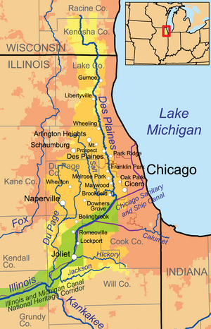
The Des Plaines River (/dɪsˈpleɪnz/ diss-PLAYNZ) is a river that flows southward for 133 miles (214 km)[2] through southern Wisconsin and northern Illinois[3] in the United States Midwest, eventually meeting the Kankakee River west of Channahon to form the Illinois River, a tributary of the Mississippi River.
Native Americans used the river as transportation route and portage. When French explorers and missionaries arrived in the 1600s, in what was then the Illinois Country of New France, they named the waterway La Rivière des Plaines (River of the Plains). The local Native Americans showed these early European explorers how to traverse waterways of the Des Plaines watershed to travel from Lake Michigan to the Mississippi River and its valley.
Parts of the river are now part of the Illinois Waterway and the Chicago Area Waterway System.
- ^ "USGS Current Conditions for USGS 05537980 DES PLAINES RIVER AT ROUTE 53 AT JOLIET, IL".
- ^ U.S. Geological Survey. National Hydrography Dataset high-resolution flowline data. The National Map Archived 2012-03-29 at the Wayback Machine, accessed May 13, 2011
- ^ American Heritage Dictionary of the English Language, Fourth Edition