Back Pulo-pulo Dinagat ACE جزر ديناغات Arabic دیناقات آیلندز AZB Dinagat Islands BCL Dinagat Islands CBK-ZAM Kapupud-ang Dinagat CEB Dinagat Islands German Islas Dinágat Spanish جزایر دیناگات Persian Dinagat Islands Finnish
Dinagat Islands
Mga Islang Dinagat (Filipino) | |
|---|---|
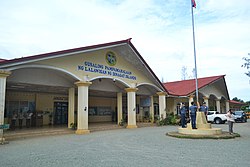
Dinagat Provincial capitol in San Jose | |
| Nickname: Mystical Island Province of Love | |
 Location in the Philippines | |
| Coordinates: 10°06′N 125°36′E / 10.1°N 125.6°E | |
| Country | Philippines |
| Region | Caraga |
| Founded | 2 December 2006 |
| Capital | San Jose |
| Largest Municipality | Basilisa |
| Government | |
| • Governor | Nilo Demerey Jr. (PFP) |
| • Vice Governor | Benglen Ecleo (PFP) |
| • Legislature | Dinagat Islands Provincial Board |
| Area | |
• Total | 1,036.34 km2 (400.13 sq mi) |
| • Rank | 75th out of 81 |
| Highest elevation | 939 m (3,081 ft) |
| Population (2020 census)[2] | |
• Total | 128,117 |
| • Rank | 77th out of 81 |
| • Density | 120/km2 (320/sq mi) |
| • Rank | 65th out of 81 |
| Divisions | |
| • Independent cities | 0 |
| • Component cities | 0 |
| • Municipalities | |
| • Barangays | 100 |
| • Districts | Legislative district of Dinagat Islands |
| Time zone | UTC+8 (PHT) |
| IDD : area code | +63 (0)86 |
| ISO 3166 code | PH-DIN |
| Spoken languages | |
| Income classification | 4th class |
| Website | dinagatislands |
Dinagat Islands (Cebuano: Mga Pulo sa Dinagat; Surigaonon: Mga Puyo nan Dinagat; Kabalian: Mga Puyo san Dinagat; Waray: Mga Purô han Dinagat; Filipino: Mga Islang Dinagat[3]), officially the Province of Dinagat Islands, is an island province in the Caraga region of the Philippines, located on the south side of Leyte Gulf. The island of Leyte is to its west, across Surigao Strait, and mainland Mindanao is to its south. Its main island, Dinagat, is about 60 kilometres (37 mi) from north to south. San Jose serves as its provincial capital while Basilisa is the most populous town in the province.
- ^ "List of Provinces". PSGC Interactive. Makati City, Philippines: National Statistical Coordination Board. Archived from the original on 17 January 2013. Retrieved 27 March 2013.
- ^ Census of Population (2020). Table B - Population and Annual Growth Rates by Province, City, and Municipality - By Region. Philippine Statistics Authority. Retrieved 8 July 2021.
- ^ "Mapa ng mga Wika (Rehiyon) - CARAGA" (in Filipino). Commission on the Filipino Language. Archived from the original on 5 November 2022. Retrieved 23 September 2021.


