Back Dnjepr Afrikaans دنيبر Arabic نهر دنيبر ARZ Ríu Dniéper AST Dnipro (kuksa) AVK Dnepr çayı Azerbaijani دنیپر چایی AZB Днепр Bashkir Tukad Dnieper BAN Дняпро Byelorussian
| Dnieper | |
|---|---|
 Dnieper in Kyiv | |
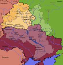
 Dnieper River drainage basin (lighter tones) | |
 | |
| Native name |
|
| Location | |
| Countries | |
| Cities | |
| Physical characteristics | |
| Source | |
| • location | Valdai Hills, Russia |
| • coordinates | 55°52′18.08″N 33°43′27.08″E / 55.8716889°N 33.7241889°E |
| • elevation | 220 m (720 ft) |
| Mouth | Dnieper Delta |
• location | Ukraine |
• coordinates | 46°30′00″N 32°20′00″E / 46.50000°N 32.33333°E |
• elevation | 0 m (0 ft) |
| Length | 2,201 km (1,368 mi) |
| Basin size | 504,000 km2 (195,000 sq mi) |
| Discharge | |
| • location | Kherson |
| • average | 1,670 m3/s (59,000 cu ft/s) |
| Basin features | |
| Tributaries | |
| • left | Sozh, Desna, Trubizh, Supiy, Sula, Psel, Vorskla, Samara, Konka (Kherson Oblast), Konka (Zaporizhzhia Oblast), Bilozerka |
| • right | Drut, Berezina, Pripyat, Teteriv, Irpin, Stuhna, Ros, Tiasmyn, Bazavluk, Inhulets |
| Protection status | |
| Official name | Dnieper River Floodplain |
| Designated | 29 May 2014 |
| Reference no. | 2244[1] |
Settlements next to the Dnieper Towns/villages | |||||||||||||||||||||||||||||||||||||||||||||||||||||||||||||||||||||||||||||||||||||||||||||||||||||||||||||||||||||||||||||||||||||||||||||||||||||||||||||||||||||||||||||||||||||||||||||||||||||||||||||||||||||||||||||||||||||||||||||||||||||||||||||||||||||||||||||||||||||||||||||||||||||||||||||||||||||||||||||||||||||||||||||||||||||||||||||||||||||||||||||||||||||||||||||||||
|---|---|---|---|---|---|---|---|---|---|---|---|---|---|---|---|---|---|---|---|---|---|---|---|---|---|---|---|---|---|---|---|---|---|---|---|---|---|---|---|---|---|---|---|---|---|---|---|---|---|---|---|---|---|---|---|---|---|---|---|---|---|---|---|---|---|---|---|---|---|---|---|---|---|---|---|---|---|---|---|---|---|---|---|---|---|---|---|---|---|---|---|---|---|---|---|---|---|---|---|---|---|---|---|---|---|---|---|---|---|---|---|---|---|---|---|---|---|---|---|---|---|---|---|---|---|---|---|---|---|---|---|---|---|---|---|---|---|---|---|---|---|---|---|---|---|---|---|---|---|---|---|---|---|---|---|---|---|---|---|---|---|---|---|---|---|---|---|---|---|---|---|---|---|---|---|---|---|---|---|---|---|---|---|---|---|---|---|---|---|---|---|---|---|---|---|---|---|---|---|---|---|---|---|---|---|---|---|---|---|---|---|---|---|---|---|---|---|---|---|---|---|---|---|---|---|---|---|---|---|---|---|---|---|---|---|---|---|---|---|---|---|---|---|---|---|---|---|---|---|---|---|---|---|---|---|---|---|---|---|---|---|---|---|---|---|---|---|---|---|---|---|---|---|---|---|---|---|---|---|---|---|---|---|---|---|---|---|---|---|---|---|---|---|---|---|---|---|---|---|---|---|---|---|---|---|---|---|---|---|---|---|---|---|---|---|---|---|---|---|---|---|---|---|---|---|---|---|---|---|---|---|---|---|---|---|---|---|---|---|---|---|---|---|---|---|---|---|---|---|---|---|---|---|---|---|---|---|---|---|---|---|---|---|---|---|---|---|---|---|---|---|---|---|---|---|---|---|---|---|---|---|---|---|---|---|
| blank spaces indicate as place above (") | |||||||||||||||||||||||||||||||||||||||||||||||||||||||||||||||||||||||||||||||||||||||||||||||||||||||||||||||||||||||||||||||||||||||||||||||||||||||||||||||||||||||||||||||||||||||||||||||||||||||||||||||||||||||||||||||||||||||||||||||||||||||||||||||||||||||||||||||||||||||||||||||||||||||||||||||||||||||||||||||||||||||||||||||||||||||||||||||||||||||||||||||||||||||||||||||||
| |||||||||||||||||||||||||||||||||||||||||||||||||||||||||||||||||||||||||||||||||||||||||||||||||||||||||||||||||||||||||||||||||||||||||||||||||||||||||||||||||||||||||||||||||||||||||||||||||||||||||||||||||||||||||||||||||||||||||||||||||||||||||||||||||||||||||||||||||||||||||||||||||||||||||||||||||||||||||||||||||||||||||||||||||||||||||||||||||||||||||||||||||||||||||||||||||
The Dnieper (/(də)ˈniːpər/ (də)-NEE-pər), also called Dnepr or Dnipro (/dəˈniːproʊ/ də-NEE-proh),[a] is one of the major transboundary rivers of Europe, rising in the Valdai Hills near Smolensk, Russia, before flowing through Belarus and Ukraine to the Black Sea. Approximately 2,200 km (1,400 mi) long,[2] with a drainage basin of 504,000 square kilometres (195,000 sq mi), it is the longest river of Ukraine and Belarus and the fourth-longest river in Europe, after the Volga, Danube, and Ural rivers.[3]
In antiquity, the river was part of the Amber Road trade routes. During the Ruin in the later 17th century, the area was contested between the Polish–Lithuanian Commonwealth and Russia, dividing what is now Ukraine into areas described by its right and left banks. During the Soviet period, the river became noted for its major hydroelectric dams and large reservoirs. The 1986 Chernobyl disaster occurred on the Pripyat River, a tributary of the Dnieper, just upstream from its confluence with the Dnieper. The Dnieper is an important navigable waterway for the economy of Ukraine and is connected by the Dnieper–Bug Canal to other waterways in Europe. During the 2022 Russian invasion of Ukraine, certain segments of the river were made part of the defensive lines between territory controlled by the Russians and the Ukrainians.[4][5][6]
- ^ "Dnieper River Floodplain". Ramsar Sites Information Service. Retrieved 25 April 2018.
- ^ "Main Geographic Characteristics of the Republic of Belarus. Main characteristics of the largest rivers of Belarus". Land of Ancestors. Data of the Ministry of Natural Resources and Environmental Protection of the Republic of Belarus. 2011. Retrieved 27 September 2013.
- ^ "Dnieper River". www.britannica.com. Retrieved 25 May 2022.
- ^ Cooper, Helene; Schmitt, Eric; Barnes, Julian E. (12 November 2022). "Winter Will Be a Major Factor in the Ukraine War, Officials Say". The New York Times. ISSN 0362-4331. Retrieved 12 November 2022.
- ^ Ovsyaniy, Kyrylo. "Russian Forces Digging Trenches, Fortifications On Banks Of Dnieper River, Satellite Imagery Shows". RadioFreeEurope/RadioLiberty. Retrieved 12 November 2022.
- ^ "Ukraine in 'final stage' of reclaiming west bank of Dnipro River". Reuters. 11 November 2022. Retrieved 12 November 2022.
Cite error: There are <ref group=lower-alpha> tags or {{efn}} templates on this page, but the references will not show without a {{reflist|group=lower-alpha}} template or {{notelist}} template (see the help page).