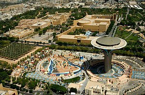
Downtown Riyadh
وسط الرياض | |
|---|---|
 | |
 | |
| Coordinates: 24°38′47″N 46°42′55″E / 24.64627°N 46.71524°E | |
| Country | Saudi Arabia |
| City | Riyadh |
| Baladiyah | Al-Batʼha Al-Malaz Al-Shumaisi |
| Downtown Development Plan | 2013 |
| Neighborhoods of Downtown | |
Downtown Riyadh (Arabic: وسط الرياض, lit. 'middle Riyadh') is a term used for a group of 20 neighborhoods in Riyadh, Saudi Arabia. Covering an area of more than 3700 acres, it hosts some of the city's most important cultural and commercial districts, such as the King Abdulaziz Historical Center, the al-Batʼha commercial area and the Qasr al-Hukm District, while simultaneously overlapping with many of the old city areas of the capital metropolis, including the erstwhile walled town. The first downtown development plan was introduced in 2013 by the Royal Commission for Riyadh City.[1][2]
The downtown is bounded by Al-Washm Street and Omar bin Al-Khattab Street in the north, Al-Kharj Road in the east, Ammar bin Yasir Street and Al-A’sha Street in the south, and Imam Abdulaziz bin Muhammad Street in the west.
- ^ "تحويل وسط العاصمة إلى مركز تاريخي وإداري وثقافي". www.alriyadh.com. 6 March 2013. Retrieved 1 February 2024.
- ^ "تطوير "الظهيرة والدحو" وأسواق السويلم والبطحاء والعطايف واستقطاب مشروعات الإسكان". www.alriyadh.com. 6 February 2014. Retrieved 1 February 2024.
