Back درونفیلد AZB Dronfield (lungsod) CEB Dronfield Welsh Dronfield German Dronfield Spanish Dronfield Basque درونفیلد Persian Dronfield French Dronfield Irish Dronfield Italian
| Dronfield | |
|---|---|
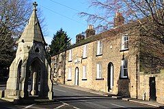
 Peel Monument and High Street | |
Location within Derbyshire | |
| Population | 21,261 (2011 census) |
| OS grid reference | SK355785 |
| District | |
| Shire county | |
| Region | |
| Country | England |
| Sovereign state | United Kingdom |
| Post town | DRONFIELD |
| Postcode district | S18 |
| Dialling code | 01246 |
| Police | Derbyshire |
| Fire | Derbyshire |
| Ambulance | East Midlands |
| UK Parliament | |
Dronfield is a town in North East Derbyshire, England, which includes Dronfield Woodhouse and Coal Aston. It lies in the valley of the River Drone between Chesterfield and Sheffield. The Peak District National Park is three miles (4.8 km) to the west. The name comes from the Old English Dranfleld, probably meaning an open land infested with drone bees.[1]
The town existed before the 1086 Domesday Book, and has a 13th-century parish church. In 1662, Charles II granted the town a market, although this later ceased. The industrial history of the town includes coal mining, the wool trade, the production of soap and steel, and engineering. Today a range of manufacturing firms still operate in the town. The stadium to the north of the town is officially "The Home of Football", providing the playing surface for Sheffield F.C., the world's oldest football club.[2]
Dronfield's population increased in the post-war years from 6,500 in 1945 to 21,261 in the 2011 Census.[3]
- ^ "Dronfield History | Peak District Online". Peak District Online.
- ^ Club address
- ^ "Area: Dronfield (Parish), Key Figures for 2011 Census". Neighbourhood Statistics. Office for National Statistics. Retrieved 24 March 2016.
