Back مقاطعة دوندي (نبراسكا) Arabic Dundy County, Nebraska BAR Дънди (окръг) Bulgarian ডান্দ্য কাউন্টি, নেব্রাস্কা BPY Dundy Gông (Nebraska) CDO Данди (гуо, Небраска) CE Dundy County CEB Dundy County, Nebraska Welsh Dundy County German Κομητεία Ντάντι (Νεμπράσκα) Greek
Dundy County | |
|---|---|
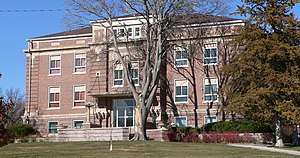
 Dundy County Courthouse in Benkelman | |
 Location within the U.S. state of Nebraska | |
 Nebraska's location within the U.S. | |
| Coordinates: 40°11′N 101°41′W / 40.18°N 101.69°W | |
| Country | |
| State | |
| Founded | 1873 (authorized) 1884 (organized) |
| Named for | Elmer Scipio Dundy |
| Seat | Benkelman |
| Largest city | Benkelman |
| Area | |
• Total | 921 sq mi (2,390 km2) |
| • Land | 920 sq mi (2,400 km2) |
| • Water | 1.2 sq mi (3 km2) 0.1% |
| Population (2020) | |
• Total | 1,654 |
| • Density | 2.0/sq mi (0.8/km2) |
| Time zone | UTC−7 (Mountain) |
| • Summer (DST) | UTC−6 (MDT) |
| Congressional district | 3rd |
| Website | www |
Dundy County is a county in the U.S. state of Nebraska. As of the 2020 United States Census, the population was 1,654.[1] Its county seat is Benkelman.[2]
In the Nebraska license plate system, Dundy County is represented by the prefix 76 (it had the seventy-sixth-largest number of vehicles registered in the county when the license plate system was established in 1922).
- ^ "US Census Bureau". US Census Bureau. Archived from the original on May 1, 2022. Retrieved April 30, 2020.
- ^ "Find a County". National Association of Counties. Archived from the original on July 4, 2012. Retrieved June 7, 2011.