Back مقاطعة دونكلين (ميزوري) Arabic Dunklin County, Missouri BAR Дънклин (окръг, Мисури) Bulgarian ডানক্লিন কাউন্টি, মিসৌরি BPY Dunklin Gông (Missouri) CDO Данклин (гуо, Миссури) CE Dunklin County CEB Dunklin County, Missouri Welsh Dunklin County German Condado de Dunklin Spanish
Dunklin County | |
|---|---|
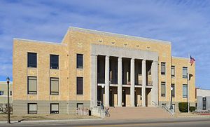
 Dunklin County Courthouse in Kennett | |
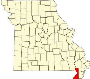
 Location within the U.S. state of Missouri | |
 Missouri's location within the U.S. | |
| Coordinates: 36°16′N 90°05′W / 36.27°N 90.09°W | |
| Country | |
| State | |
| Founded | February 14, 1845 |
| Named for | Daniel Dunklin |
| Seat | Kennett |
| Largest city | Kennett |
| Area | |
• Total | 547 sq mi (1,420 km2) |
| • Land | 541 sq mi (1,400 km2) |
| • Water | 6.1 sq mi (16 km2) 1.1% |
| Population (2020) | |
• Total | 28,283 |
| • Density | 52/sq mi (20/km2) |
| Time zone | UTC−6 (Central) |
| • Summer (DST) | UTC−5 (CDT) |
| Congressional district | 8th |
| Website | dunklincounty |
Dunklin County is located in the Bootheel of the U.S. state of Missouri. As of the 2020 census, the population was 28,283.[1] The largest city and county seat is Kennett.[2]
Dunklin County comprises the Kennett, MO Micropolitan Statistical Area.
- ^ "Explore Census Data". Data.census.gov. Retrieved March 20, 2022.
- ^ "Find a County". National Association of Counties. Archived from the original on July 12, 2012. Retrieved June 7, 2011.