This article needs additional citations for verification. (November 2023) |
Eastern Indonesia | |
|---|---|
| Kawasan Timur Indonesia[1] Indonesia Timur (in Indonesian) | |
|
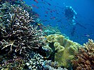
From upper-left to lower-right: Diving experience in Piaynemo Island of Raja Ampat, Clitoria ternatea (the native flower of Ternate Island), Pura Ulun Danu Bratan, Bali (Bali's most popular Hindu temple) Papeda (the staple food of Eastern Indonesia) | |
 Eastern Region of Indonesia | |
| Largest city | Makassar |
| Provinces | 17 Provinces |
| Demonym | Eastern Indonesians[2] |
| Time zones | UTC+8 (Central Indonesia Time) |
| UTC+9 (Eastern Indonesia Time) | |
Eastern Indonesia (or East Indonesia)[3] is one of the two main geographical regions of Indonesia, the other being Western Indonesia.[1] Eastern Indonesia spans across the Banda and Maluku Seas in the west, the Arafura and Timor Seas in the south, and the Halmahera Sea in the north. It comprises the archipelagic territory of Tanimbar, Banda, Maluku,[4] Halmahera, Raja Ampat, Biak, and Western New Guinea. Central Indonesian Time and Eastern Indonesia Time are the national standard time designated for Eastern Indonesia; it falls within the UTC+8 and UTC+9 time zone, respectively.
Eastern Indonesia borders Southern Philippines in the Northwest, Palau in the North, Papua New Guinea in the East, and Northern Australia in the South.
- ^ a b "Jejak Lensa Pembangunan Perhubungan Papua, NTB, NTT Kementerian Perhubungan Republik Indonesia". Kementerian Perhubungan Republik Indonesia (in Indonesian). Retrieved 2024-04-22.
- ^ Williams, Catharina Purwani (2007). Maiden Voyages: Eastern Indonesian Women on the Move. Netherlands: Koninklijk Instituut voor Taal-, Land- en Volkenkunde (KITLV) Press. p. 211. ISBN 9789812303943.
- ^ "President Jokowi: East Indonesia Will Be Able to Expand Rapidly, Need Supported by Infrastructure". Cabinet Secretariat of the Republic of Indonesia. 2015.
- ^ Cite error: The named reference
JakartaPostwas invoked but never defined (see the help page).


