Back Eckington (parokya sa Hiniusang Gingharian, Derbyshire) CEB Eckington, Swydd Derby Welsh Eckington (Derbyshire) Spanish Eckington (Derbyshire) Basque اکینگتون، دربیشر Persian Eckington (Derbyshire) French Eckington, Derbyshire Irish Eckington (Derbyshire) Italian Eckington (Derbyshire) LLD Eckington (Derbyshire) Dutch
| Eckington | |
|---|---|
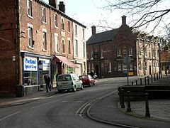
 Eckington village centre (2006) | |
Location within Derbyshire | |
| Area | 17.077 sq mi (44.23 km2) |
| Population | 11,855 (2011)[1] |
| • Density | 694/sq mi (268/km2) |
| OS grid reference | SK434749 |
| • London | 135.34 mi (217.81 km) |
| Civil parish |
|
| District | |
| Shire county | |
| Region | |
| Country | England |
| Sovereign state | United Kingdom |
| Post town | SHEFFIELD |
| Postcode district | S21 |
| Dialling code | 01246 |
| Police | Derbyshire |
| Fire | Derbyshire |
| Ambulance | East Midlands |
| UK Parliament | |
| Website | Eckington Parish Council |
Eckington is a town[2] and civil parish in North East Derbyshire, England. It is 7 miles (11 km) northeast of Chesterfield and 9 miles (14 km) southeast of Sheffield, on the border with South Yorkshire. It lies on the B6052 and B6056 roads close to the A6135 for Sheffield and Junction 30 of the M1. It had a 2001 population of 11,152,[3] increasing to 11,855 (including the parish of Bramley, Renishaw, Marsh Lane and Troway) at the 2011 Census.[1]
- ^ a b "Eckington Parish Local Area Report". nomisweb.co.uk. Office for National Statistics. Retrieved 23 October 2023.
- ^ "Eckington Parish Council". eckington-pc.gov.uk. Eckington Parish Council. Retrieved 2 January 2023.
- ^ "Neighbourhood Statistics". Office for National Statistics. Retrieved 3 January 2015.
