Back جبل ال پانيسيلو ARZ El Panecillo German El Panecillo Spanish El Panecillo French El Panecillo Italian El Panecillo LLD El Panecillo Dutch 埃尔巴奈西由火山 Chinese
This article needs additional citations for verification. (October 2008) |


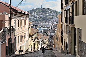
El Panecillo (from Spanish panecillo small piece of bread, diminutive of pan bread) is a 200-metre-high hill of volcanic-origin, with loess soil, located between southern and central Quito. Its peak is at an elevation of 3,016 metres (9,895 ft) above sea level. The original name used by the aboriginal inhabitants of Quito was Yavirac. According to Juan de Velasco, a Jesuit historian, there was a temple on top of Yavirac where the Indians worshiped the sun until it was destroyed by the Spanish conquistadores. The street that leads up to El Panecillo is named after Melchor Aymerich.