Back Distrito electoral (Canadá) Spanish Circonscriptions électorales du Canada French Избирательный округ (Канада) Russian Electoral district (Canada) SIMPLE Виборчі округи Канади Ukrainian

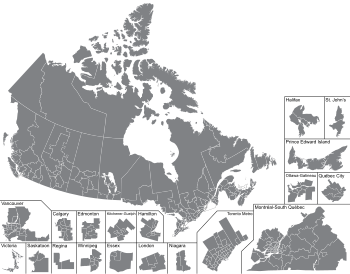
An electoral district in Canada is a geographical constituency upon which Canada's representative democracy is based. It is officially known in Canadian French as a circonscription but frequently called a comté (county). In Canadian English it is also colloquially and more commonly known as a riding or constituency.
Each federal electoral district returns one Member of Parliament (MP) to the House of Commons of Canada; each provincial or territorial electoral district returns one representative—called, depending on the province or territory, Member of the Legislative Assembly (MLA), Member of the National Assembly (MNA), Member of Provincial Parliament (MPP) or Member of the House of Assembly (MHA)—to the provincial or territorial legislature.
Since 2015, there have been 338 federal electoral districts in Canada. In provincial and territorial legislatures, the provinces and territories each set their own number of electoral districts independently of their federal representation. The province of Ontario currently defines most of its provincial electoral districts to align with federal boundaries; no other province does so, and even Ontario maintains a few variances from federal boundaries. The ward boundaries of Toronto City Council also correspond to federal electoral district boundaries, although they are numbered rather than using the federal names.
Elections Canada is the independent body set up by Parliament to oversee Canadian federal elections, while each province and territory has its own separate elections agency to oversee the provincial and territorial elections.