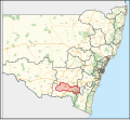
| Wagga Wagga New South Wales—Legislative Assembly | |||||||||||||||
|---|---|---|---|---|---|---|---|---|---|---|---|---|---|---|---|
Interactive map of district boundaries from the 2023 state election | |||||||||||||||
| State | New South Wales | ||||||||||||||
| Dates current | 1894–1904 1913–1920 1927–present | ||||||||||||||
| MP | Joe McGirr | ||||||||||||||
| Party | Independent | ||||||||||||||
| Namesake | Wagga Wagga | ||||||||||||||
| Electors | 57,413 (2023) | ||||||||||||||
| Area | 12,108.11 km2 (4,675.0 sq mi) | ||||||||||||||
| Demographic | Provincial and rural | ||||||||||||||
| |||||||||||||||
Wagga Wagga is an electoral district of the Legislative Assembly in the Australian state of New South Wales. The district has been held by Independent MP Joe McGirr since the September 2018 by-election.
Wagga Wagga is a regional electorate. It entirely covers two local government areas: the City of Wagga Wagga and Lockhart Shire. It also covers part of the Snowy Valleys Council, which was established following the merger of Tumut Shire and Tumbarumba Shire.[1]
- ^ "Wagga Wagga". New South Wales Electoral Commission. Retrieved 23 November 2019.


