Back Enfield (lungsod sa Kanada) CEB Enfield (Nova Scotia) Finnish Enfield (Nouvelle-Écosse) French Enfield, Nova Scotia SIMPLE Enfield, Nova Scotia Swedish
Enfield | |
|---|---|
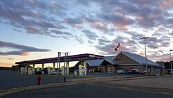
 Truck stop in Enfield | |
 Interactive map of Enfield | |
| Coordinates: 44°56′36″N 63°32′10″W / 44.94333°N 63.53611°W[1] | |
| Country | |
| Province | |
| Municipality | Halifax Regional Municipality East Hants Municipality |
| District | 10[2] |
| Founded | 1862 |
| Named for | Enfield, Connecticut |
| Government | |
| • Type | Regional Council |
| • Governing body | Municipal Council of East Hants |
| Area | |
| • Land | 11.67 km2 (4.51 sq mi) |
| Highest elevation | 124 m (407 ft) |
| Lowest elevation | 8 m (26 ft) |
| Population | |
• Total | 6,583 |
| • Density | 563.9/km2 (1,460/sq mi) |
| Time zone | UTC-4 (AST) |
| • Summer (DST) | UTC-3 (ADT) |
| Postal code | B2T |
| Area code | 902 |
| GNBC Code | CALHK[1] |
Enfield is an unincorporated community in the Canadian province of Nova Scotia, located in both East Hants Municipality and Halifax Regional Municipality. Enfield is situated along the Shubenacadie River and its source at Grand Lake, and is directly adjacent to the community of Elmsdale. The area encompassing Enfield, Elmsdale, Lantz, and Milford is colloquially referred to as "The Corridor".[5] The namesake of Enfield is the town of Enfield, Connecticut, the former residence of an early settler.
- ^ a b "Place names: Enfield". Canadian Geographical Names Database. Natural Resources Canada. Retrieved 30 January 2025.
- ^ "East Hants Municipal Electoral Districts 2024" (PDF). Municipality of East Hants. Retrieved 30 January 2025.
- ^ a b "2021 Census of Population". Ottawa: Statistics Canada. 15 November 2023. Statistics Canada Catalogue no. 98-316-X2021001. Retrieved 30 January 2025.
- ^ Cite error: The named reference
NORMALSwas invoked but never defined (see the help page). - ^ "Regions". Municipality of East Hants. 2021. Retrieved 31 January 2025.