Back فولز تشيرش Arabic Folls-Çörç Azerbaijani فالس چورچ، ویرجینیا AZB Falls Church BAR Фолс-Черч CE Falls Church CEB Falls Church DAG Falls Church German Falls Church Spanish Falls Church city konderria (Virginia) Basque
Falls Church, Virginia | |
|---|---|
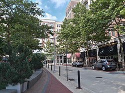
 Downtown Falls Church | |
 Location of Falls Church in Virginia | |
 Falls Church highlighted red in the Commonwealth of Virginia | |
| Coordinates: 38°53′09″N 77°10′20″W / 38.88583°N 77.17222°W | |
| Country | |
| State | |
| Settled | c. 1699 |
| Incorporated (town) | 1875 |
| Incorporated (city) | 1948 |
| Government | |
| • Type | Council–manager |
| • Mayor | Letty Hardi[1] |
| Area | |
• Total | 2.05 sq mi (5.30 km2) |
| • Land | 2.05 sq mi (5.30 km2) |
| • Water | 0.00 sq mi (0.00 km2) |
| Elevation | 328 ft (99 m) |
| Population (2020) | |
• Total | 14,658 |
| • Density | 7,200/sq mi (2,800/km2) |
| Time zone | UTC−5 (EST) |
| • Summer (DST) | UTC−4 (EDT) |
| ZIP Codes | 22040, 22042, 22044, 22046 |
| Area code(s) | 703 and 571 |
| FIPS code | 51-27200 |
| GNIS feature ID | 1495526[3] |
| Website | fallschurchva |
| Sister city is Kokolopori, Democratic Republic of Congo | |
Falls Church is an independent city in the Commonwealth of Virginia, United States.[3] As of the 2020 census, the population was 14,658.[4] Falls Church is part of both Northern Virginia and the Washington metropolitan area. As of 2020, it has a median household income of $146,922, the second-highest household income of any county in the nation behind Loudoun County, Virginia.
Taking its name from the Falls Church, an 18th-century Church of England, later the Episcopal Church, Falls Church gained township status within Fairfax County in 1875.
In 1948, it seceded from Fairfax County and was incorporated as the City of Falls Church, an independent city with county-level governance status although it is not nominally a county.[5]
The city's corporate boundaries do not include all of the area historically known as Falls Church; these areas include portions of Seven Corners and other portions of the current Falls Church postal districts in Fairfax County and Arlington County, known as East Falls Church, which was part of the town of Falls Church from 1875 to 1936.[6] For statistical purposes, the U.S. Department of Commerce's Bureau of Economic Analysis combines the City of Falls Church with Fairfax City and Fairfax County.
At 2.11 square miles, Falls Church is the smallest incorporated municipality in the Commonwealth of Virginia and the smallest county-equivalent municipality in the United States.
- ^ https://www.fallschurchva.gov/384/City-Council
- ^ "2019 U.S. Gazetteer Files". United States Census Bureau. Retrieved August 7, 2020.
- ^ a b "Falls Church". Geographic Names Information System. United States Geological Survey, United States Department of the Interior.
- ^ "Falls Church city, Falls Church city, Virginia". United States Census Bureau. Retrieved January 30, 2022.
- ^ "Municipal Code of the City of Falls Church: Incorporation and Boundaries". Library1.municode.com:80. Archived from the original on January 21, 2012. Retrieved May 14, 2012.
- ^ Gernard and Netherton, Falls Church: A Virginia Village Revisited, p.65.


