Back Fano AN فانو Arabic فانو (تجمع سكان فى مقاطعه بيزارو واوربينو) ARZ Fano AVK Fano Azerbaijani فانو (ایتالیا) AZB Фано Bulgarian Fano Breton Fano Catalan Фано (гӀала) CE
Fano | |
|---|---|
| Comune di Fano | |
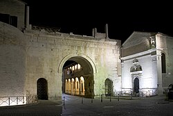
 Arch of Augustus | |
 Fano within the Province of Pesaro-Urbino | |
| Coordinates: 43°50′33″N 13°0′49″E / 43.84250°N 13.01361°E | |
| Country | Italy |
| Region | Marche |
| Province | Pesaro e Urbino (PU) |
| Frazioni | Bellocchi, Caminate, Carignano, Carrara di Fano, Centinarola, Cuccurano, Falcineto, Fenile, Magliano, Marotta, Metaurilia, Ponte Sasso, Roncosambaccio, Rosciano, Sant'Andrea in Villis, Torrette di Fano, Tre Ponti |
| Government | |
| • Mayor | Luca Serfilippi (Lega) |
| Area | |
• Total | 121 km2 (47 sq mi) |
| Elevation | 12 m (39 ft) |
| Population (31 December 2017)[2] | |
• Total | 60,978 |
| • Density | 500/km2 (1,300/sq mi) |
| Demonym | Fanesi |
| Time zone | UTC+1 (CET) |
| • Summer (DST) | UTC+2 (CEST) |
| Postal code | 61032 |
| Dialing code | 0721 |
| Patron saint | Saint Paternian |
| Saint day | 10 July |
| Website | Official website |
Fano (Italian: [ˈfaːno]) is a town and comune of the province of Pesaro and Urbino in the Marche region of Italy. It is a beach resort 12 kilometres (7 miles) southeast of Pesaro, located where the Via Flaminia reaches the Adriatic Sea. It is the third city in the region by population after Ancona and Pesaro.
- ^ "Superficie di Comuni Province e Regioni italiane al 9 ottobre 2011". Italian National Institute of Statistics. Retrieved 16 March 2019.
- ^ "Popolazione Residente al 1° Gennaio 2018". Italian National Institute of Statistics. Retrieved 16 March 2019.


