This article needs additional citations for verification. (July 2016) |
| Fenham | |
|---|---|
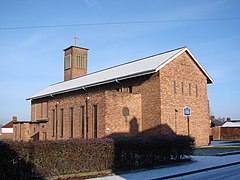
 Church of the Holy Cross, Fenham | |
Location within Tyne and Wear | |
| Population | 10,954 (2011.ward)[1] |
| OS grid reference | NZ220656 |
| Metropolitan borough | |
| Metropolitan county | |
| Region | |
| Country | England |
| Sovereign state | United Kingdom |
| Post town | NEWCASTLE UPON TYNE |
| Postcode district | NE4 |
| Dialling code | 0191 |
| Police | Northumbria |
| Fire | Tyne and Wear |
| Ambulance | North East |
| UK Parliament | |
Fenham is an area of the west-end of Newcastle upon Tyne, in the county of Tyne and Wear, England. It lies to the west of the city centre, and is bounded on the north and east by a large area of open land known as the Town Moor. To the south lies Benwell, West Denton lies to the west, Blakelaw and Cowgate to the north, and Arthur's Hill and Spital Tongues to the east. Until 1974 it was in Northumberland.
As of 2018, the area covers two wards of Newcastle: Wingrove Ward, and West Fenham Ward.
Fenham grew up as a separate township from Newcastle, lying on the western outskirts of the city. Much of the land originally belonged to religious charitable institutions, and there are covenant restrictions on the building of any licensed premises.
- ^ "Ward population 2011". Archived from the original on 14 July 2015. Retrieved 5 July 2015.

