Back 8.º distrito congresional de Florida Spanish حوزه انتخابیه هشتم فلوریدا Persian Huitième district congressionnel de Floride French
This article needs to be updated. (October 2020) |
| Florida's 8th congressional district | |
|---|---|
Interactive map of district boundaries since January 3, 2023 | |
| Representative | |
| Area | 2,412[1] sq mi (6,250 km2) |
| Distribution |
|
| Population (2023) | 817,216[3] |
| Median household income | $76,967[4] |
| Ethnicity |
|
| Cook PVI | R+11[5] |
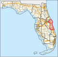
Florida's 8th congressional district is an electoral district for the U.S. Congress and was reassigned in 2012, effective January 2013, from the inland central part of Florida to the central Atlantic coast. The district includes Titusville, Melbourne, Cocoa, and Cape Canaveral, Florida. The district includes all of Brevard County, as well as all of Indian River County and parts of Orange County. The district also includes the Kennedy Space Center.[6][7]
Currently, the residents of the Eighth District are represented by Republican Mike Haridopolos, who has held the seat since 2025.
- ^ "Congressional Plan--SC14-1905 (Ordered by The Florida Supreme Court, 2-December-2015)" (PDF). Florida Senate Committee on Reapportionment. Retrieved January 11, 2017.
- ^ "Congressional Districts Relationship Files (state-based)". www.census.gov. US Census Bureau Geography.
- ^ "My Congressional District". www.census.gov. Center for New Media & Promotion (CNMP), US Census Bureau.
- ^ "My Congressional District".
- ^ "2022 Cook PVI: District Map and List". Cook Political Report. Retrieved January 10, 2023.
- ^ See whole Florida state map for 2013, with the 8th district covering Brevard County and Indian River County: h9047_35x42L.pdf Congressional Plan: H000C9047. Chapter No. 2012-2, Laws of Florida. www.flsenate.gov. February 16, 2012.
- ^ See the 2013 boundaries of the 8th district, covering Brevard County and eastern Orange and Indian River County in the 2013 districts map: H000C9047_map_ec.pdf, for the eastern central region of Florida. Congressional Plan: H000C9047. Chapter No. 2012-2, Laws of Florida. www.flsenate.gov. February 2012.

