Back Форе Bulgarian Vorst Breton Vorst Catalan Vorst CEB Forest/Vorst German Vorst (Belgio) Esperanto Forest (Bélgica) Spanish Forest (Brüssel) Estonian Forest (Belgika) Basque فوره (بلژیک) Persian
Forest
| |
|---|---|
 | |
| Coordinates: 50°48′47″N 04°19′29″E / 50.81306°N 4.32472°E | |
| Country | |
| Community | Flemish Community French Community |
| Region | Brussels-Capital |
| Arrondissement | Brussels-Capital |
| Government | |
| • Mayor | Mariam El Hamidine (Ecolo) |
| • Governing party/ies | Ecolo-Groen, LB |
| Area | |
• Total | 6.29 km2 (2.43 sq mi) |
| Population (2020-01-01)[1] | |
• Total | 56,581 |
| • Density | 9,000/km2 (23,000/sq mi) |
| Postal codes | 1190 |
| NIS code | 21007 |
| Area codes | 02 |
| Website | forest.irisnet.be |
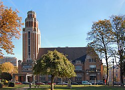
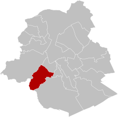
Forest (French, pronounced [fɔʁɛ]) or Vorst (Dutch, pronounced [vɔrst] ⓘ), is one of the 19 municipalities of the Brussels-Capital Region, Belgium. Located in the southern part of the region, it is bordered by Anderlecht, Ixelles, Uccle, and Saint-Gilles, as well as the Flemish municipality of Drogenbos. In common with all of Brussels' municipalities, it is legally bilingual (French–Dutch).
As of 1 January 2022[update], the municipality had a population of 56,616 inhabitants.[2] The total area is 6.29 km2 (2.43 sq mi), which gives a population density of 8,998/km2 (23,300/sq mi).[2]
The municipality is commonly known for Forest National/Vorst Nationaal concert hall. It houses an Audi factory and a railway depot that is home to the Belgian fleet of Eurostar train sets. It also formerly had a prison, Forest Prison.
- ^ "Bevolking per gemeente op 1 januari 2020". Statbel.
- ^ a b "Forest | IBSA". ibsa.brussels. Retrieved 4 June 2023.


