Back قلعة شارلمونت ARZ Fort de Charlemont German Fort de Charlemont French Fort de Charlemont LB Fort Charlemont Dutch
| Fortress of Charlemont | |
|---|---|
Fort de Charlemont | |
| Near Givet | |
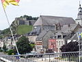
 The Fortress of Charlemont and the village of Givet. | |
 Fortress of Charlemont (Champagne-Ardenne) | |
| Coordinates | 50°08′09″N 4°48′13″E / 50.135833°N 4.803611°E |
| Type | Fort |
| Site history | |
| Built | 1555 |
The Fortress of Charlemont (French: Fort de Charlemont) is a French stronghold located near the Belgian border on the Meuse. It is a citadel, surrounded by a network of outworks,[1] including the connecting forts (Givet and the Mont d'Hours).[2] It dominates the town of Givet and when in use as a working fortress controlled the valley of the Meuse.
-
 Destruction within the fort after the First World War.
 -
 view of the fort from within Givet.
 -
 The Maugis Tower.
 -
 Between Condé Charlemont Covered Path.
 -
 Entrance to Fort Condé.
 -
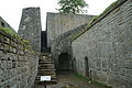 Staircase, the only access point from the glacis to the fort.


- ^ Montclos 2009, p. [page needed].
- ^ Siborne 1895, p. 780.