Back فرانيكير Arabic فرانيكير ARZ Franeker Catalan Franeker CEB Franeker Danish Franeker German Franeker Esperanto Franeker Spanish فرانکر Persian Franeker French
Franeker
Frjentsjer (West Frisian) | |
|---|---|
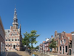
 The former city hall (left) and the Eise Eisinga Planetarium (right) | |
| Motto(s): | |
 | |
 Location in the former municipality of Franekeradeel | |
| Coordinates: 53°11′N 5°32′E / 53.183°N 5.533°E | |
| Country | Netherlands |
| Province | Friesland |
| Municipality | Waadhoeke |
| Area | |
• Total | 18.17 km2 (7.02 sq mi) |
| • Land | 17.42 km2 (6.73 sq mi) |
| • Water | 0.75 km2 (0.29 sq mi) |
| Elevation | 1.1 m (3.6 ft) |
| Population (2021)[1] | |
• Total | 13,015 |
| • Density | 720/km2 (1,900/sq mi) |
| Postal code | 8801, 8802[1] |
| Dialing code | 0517 |
| Website | www |
Franeker (Dutch pronunciation: [ˈfraːnəkər] ⓘ; West Frisian: Frjentsjer [ˈfrjɛntsjər]) is one of the eleven historical cities of Friesland and capital of the municipality of Waadhoeke. It is located north of the Van Harinxmakanaal and about 20 km west of Leeuwarden. As of 2023, it had 13,015 inhabitants.[1] World Heritage Site the Eise Eisinga Planetarium, established in 1781, is located in the city.
- ^ a b c d "Kerncijfers wijken en buurten 2023" [Key figures for districts and neighbourhoods 2023]. Statistics Netherlands. 14 March 2024. Retrieved 7 November 2024.
- ^ "AHN Viewer". Actueel Hoogtebestand Nederland (in Dutch). Het Waterschapshuis. 24 July 2019. Retrieved 7 November 2024.


