Back مقاطعة فرانكلين (ميسيسيبي) Arabic Franklin County, Mississippi BAR Франклин (окръг, Мисисипи) Bulgarian ফ্রাঙ্কলিন কাউন্টি, মিসিসিপি BPY Franklin Gông (Mississippi) CDO Франклин (гуо, Миссисипи) CE Franklin County (kondado sa Tinipong Bansa, Mississippi) CEB Franklin County (Mississippi) Czech Franklin County, Mississippi Welsh Franklin County (Mississippi) Danish
Franklin County | |
|---|---|
 Franklin County Courthouse, Meadville, Mississippi. | |
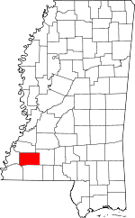
 Location within the U.S. state of Mississippi | |
 Mississippi's location within the U.S. | |
| Coordinates: 31°29′N 90°54′W / 31.48°N 90.9°W | |
| Country | |
| State | |
| Founded | 1809 |
| Named for | Benjamin Franklin |
| Seat | Meadville |
| Largest town | Bude |
| Area | |
• Total | 567 sq mi (1,470 km2) |
| • Land | 564 sq mi (1,460 km2) |
| • Water | 3.0 sq mi (8 km2) 0.5% |
| Population (2020) | |
• Total | 7,675 |
• Estimate (2023) | 7,610 |
| • Density | 14/sq mi (5.2/km2) |
| Time zone | UTC−6 (Central) |
| • Summer (DST) | UTC−5 (CDT) |
| Congressional district | 3rd |
| Website | franklincoms |
Franklin County is a county located in the U.S. state of Mississippi. As of the 2020 census, the population was 7,675.[1] Its county seat is Meadville.[2] The county was formed on December 21, 1809, from portions of Adams County and named for Founding Father Benjamin Franklin.[3] It is bisected by the Homochitto River, which runs diagonally through the county from northeast to southwest.
- ^ "Census - Geography Profile: Franklin County, Mississippi". United States Census Bureau. Retrieved January 8, 2023.
- ^ "Find a County". National Association of Counties. Archived from the original on May 31, 2011. Retrieved June 7, 2011.
- ^ Gannett, Henry (1905). The Origin of Certain Place Names in the United States. Govt. Print. Off. pp. 131.