Back مقاطعة فرانكلين (فيرجينيا) Arabic Franklin County, Virginia BAR Франклин (окръг, Вирджиния) Bulgarian ফ্রাঙ্কলিন কাউন্টি, ভার্জিনিয়া BPY Franklin Gông (Virginia) CDO Франклин (гуо, Виргини) CE Franklin County (kondado sa Tinipong Bansa, Virginia) CEB Franklin County, Virginia Welsh Franklin County (Virginia) German Κομητεία Φράνκλιν (Βιρτζίνια) Greek
Franklin County | |
|---|---|
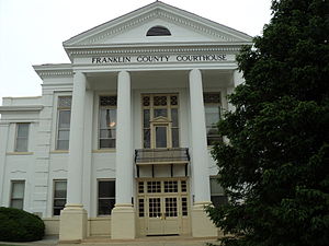
 Franklin County Courthouse in May 2010 | |
 Location within the U.S. state of Virginia | |
 Virginia's location within the U.S. | |
| Coordinates: 36°59′N 79°53′W / 36.99°N 79.88°W | |
| Country | |
| State | |
| Founded | 1785 |
| Named for | Benjamin Franklin |
| Seat | Rocky Mount |
| Largest town | Rocky Mount |
| Area | |
• Total | 712 sq mi (1,840 km2) |
| • Land | 690 sq mi (1,800 km2) |
| • Water | 21 sq mi (50 km2) 3.0% |
| Population (2020) | |
• Total | 54,477 |
| • Density | 77/sq mi (30/km2) |
| Time zone | UTC−5 (Eastern) |
| • Summer (DST) | UTC−4 (EDT) |
| Congressional district | 9th |
| Website | www |
Franklin County is a county located in the Blue Ridge foothills of the Commonwealth of Virginia. As of the 2020 census, the population was 54,477.[1] Its county seat is Rocky Mount.[2] Franklin County is part of the Roanoke Metropolitan Statistical Area and is located in the Roanoke Region of Virginia.[3] The Roanoke River forms its northeast boundary with Bedford County.
- ^ "Franklin County, Virginia". United States Census Bureau. Retrieved January 30, 2022.
- ^ "Find a County". National Association of Counties. Archived from the original on May 31, 2011. Retrieved June 7, 2011.
- ^ "Home - Roanoke Regional Partnership". Roanoke Regional Partnership. Archived from the original on June 13, 2009. Retrieved May 13, 2018.