Back فرانکتاون (کولورادو) AZB Franktown Catalan Франктаун (Колорадо) CE Franktown CEB Franktown, Colorado Welsh Franktown (Colorado) German Franktown (Colorado) Spanish Franktown (Colorado) Basque فرانکتاون (کلرادو) Persian فرنکتأؤن (کؤلؤرادؤ) GLK
Franktown, Colorado | |
|---|---|
 Franktown and the intersection of state highways 83 and 86. | |
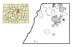
 Location of the Franktown CDP in Douglas County, Colorado | |
| Coordinates: 39°23′26″N 104°44′55″W / 39.39056°N 104.74861°W[1] | |
| Country | |
| State | |
| County | Douglas County |
| Government | |
| • Type | unincorporated community |
| Area | |
• Total | 7.661 km2 (2.958 sq mi) |
| • Land | 7.625 km2 (2.944 sq mi) |
| • Water | 0.036 km2 (0.014 sq mi) |
| Elevation | 1,889 m (6,198 ft) |
| Population | |
• Total | 409 |
| • Density | 53/km2 (140/sq mi) |
| Time zone | UTC-7 (MST) |
| • Summer (DST) | UTC-6 (MDT) |
| ZIP Code[4] | 80116 |
| Area codes | 303 & 720 |
| GNIS feature ID | 2408255[1] |
| Primary Highways | |
Franktown is an unincorporated town, a post office, and a census-designated place (CDP) located in and governed by Douglas County, Colorado, United States. The CDP is a part of the Denver–Aurora–Lakewood, CO Metropolitan Statistical Area. The Franktown post office has the ZIP Code 80116.[4] At the United States Census 2020, the population of the Franktown CDP was 409.[3]
- ^ a b c d U.S. Geological Survey Geographic Names Information System: Franktown, Colorado
- ^ "State of Colorado Census Designated Places - BAS20 - Data as of January 1, 2020". United States Census Bureau. Archived from the original on February 4, 2021. Retrieved December 21, 2020.
- ^ a b United States Census Bureau. "Franktown CDP, Colorado". Retrieved March 30, 2023.
- ^ a b "Look Up a ZIP Code". United States Postal Service. Retrieved December 21, 2020.
