Back Badia de Frobisher Catalan Frobisher Bay (luuk sa Kanada) CEB Frobisher Bay Danish Frobisher-Bucht German Bahía de Frobisher Spanish Frobisheri laht Estonian Baie de Frobisher French Frobisher-öböl Hungarian Baia di Frobisher Italian フロビッシャー湾 Japanese
| Frobisher Bay | |
|---|---|
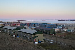
 Frobisher Bay from Iqaluit, June 2015 | |
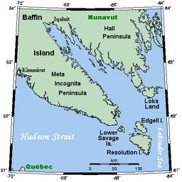
 Frobisher Bay and environs | |
| Location | Nunavut |
| Coordinates | 62°50′N 66°35′W / 62.833°N 66.583°W[1] |
| River sources | Sylvia Grinnell River |
| Ocean/sea sources | Davis Strait |
| Basin countries | Canada |
| Max. length | 230 km (140 mi) |
| Max. width | 40 km (25 mi) |
| Settlements | Iqaluit |
Frobisher Bay is an inlet of the Davis Strait in the Qikiqtaaluk Region of Nunavut, Canada. It is located in the southeastern corner of Baffin Island. Its length is about 230 km (140 mi) and its width varies from about 40 km (25 mi) at its outlet into the Davis Strait to roughly 20 km (12 mi) towards its inner end.[2]
The capital of Nunavut, Iqaluit, known as Frobisher Bay from 1942 to 1987, lies near the innermost end of the bay.
- ^ "Frobisher Bay". Geographical Names Data Base. Natural Resources Canada. 20 August 2024.
- ^ "Limits of oceans and seas" (PDF). International Hydrographic Organization (3rd ed.). 1953. Retrieved 15 February 2023.
