Back فولمر (باكينجهامشير) Arabic فولمر ARZ Фълмър Bulgarian Fulmer (lungsod) CEB Fulmer Welsh فولمر Persian Fulmer (Angleterre) French Fulmer Italian Fulmer LLD Fulmer Dutch
| Fulmer | |
|---|---|
 Allhusen Gardens, Fulmer | |
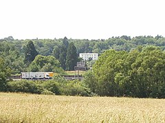
 Fulmer Hall with surrounding woods forming most of the north of the parish, taken from the M40. In the grounds are the purpose-built pharmaceutical research laboratories. | |
Location within Buckinghamshire | |
| Area | 5.58 km2 (2.15 sq mi) |
| Population | 485 (2011 census)[1] |
| • Density | 87/km2 (230/sq mi) |
| OS grid reference | SU9985 |
| Civil parish |
|
| Unitary authority | |
| Ceremonial county | |
| Region | |
| Country | England |
| Sovereign state | United Kingdom |
| Post town | Slough |
| Postcode district | SL3 |
| Dialling code | 01753 |
| Police | Thames Valley |
| Fire | Buckinghamshire |
| Ambulance | South Central |
| UK Parliament | |
Fulmer is a village and civil parish in south Buckinghamshire, England. The village has, along most of its northern border, a narrow green buffer from Gerrards Cross and its heavily wooded adjoining neighbouring villages of Iver Heath and Wexham. The village's name is derived from the Old English for "mere or lake frequented by birds". It was recorded in 1198 as Fugelmere.[2]
In the late 17th century the owners of the manor of Fulmer were forced to sell their house to their servants because they had squandered their money and could not afford to pay them. The manor then passed into the hands of the Duke of Portland.
In the mid-19th century watercress was grown at Moor Farm, known locally as "The Bog", (now Low Farm) by Richard Whiting Bradbery, the son of William Bradbery, the first British watercress pioneer who had a large cress farm at West Hyde, Hertfordshire. Richard is buried in St James churchyard, Fulmer, with his wife Hannah.
Fulmer Chase on Stoke Common Road is a former home of the Wills tobacco family and was used as a military hospital during World War II.
Fulmer is close to Pinewood Studios and several films have been shot in the village, including Those Magnificent Men in their Flying Machines and Sleepy Hollow.
- ^ "Key Statistics: Dwellings; Quick Statistics: Population Density; Physical Environment: Land Use Survey 2005". Archived from the original on 11 February 2003. Retrieved 25 January 2015.
- ^ Mills, A. D. (1996) [1991]. A Dictionary of English Place Names. Oxford: Oxford University Press. p. 138. ISBN 0192831313.
