Back غاليون (أوهايو) Arabic جاليون ARZ قالیون، اوهایو AZB Galion Catalan Галион (Огайо) CE Galion CEB Galion, Ohio Welsh Galion (Ohio) German Galion (Ohio) Spanish Galion (Ohio) Basque
Galion, Ohio | |
|---|---|
 The Galion Theatre located on Harding Way West in uptown Galion | |
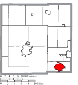
 Location of Galion in Crawford County | |
| Coordinates: 40°43′59″N 82°47′19″W / 40.73306°N 82.78861°W | |
| Country | United States |
| State | Ohio |
| Counties | Crawford, Morrow, Richland[1] |
| Government | |
| • Type | Mayor-Council |
| Area | |
• Total | 7.41 sq mi (19.20 km2) |
| • Land | 7.39 sq mi (19.15 km2) |
| • Water | 0.02 sq mi (0.05 km2) |
| Elevation | 1,165 ft (355 m) |
| Population (2020) | |
• Total | 10,453 |
• Estimate (2023)[4] | 10,293 |
| • Density | 1,413.91/sq mi (545.88/km2) |
| Time zone | UTC-5 (Eastern (EST)) |
| • Summer (DST) | UTC-4 (EDT) |
| ZIP code | 44833 |
| Area code | 419 |
| FIPS code | 39-29162[5] |
| GNIS feature ID | 1085937[3] |
| Website | http://www.galion.city |
Galion (/ˈɡæljən/ GAL-yən[6]) is a city in Crawford, Morrow, and Richland counties in the U.S. state of Ohio. The population was 10,453 at the 2020 census. Galion is the second-largest city in Crawford County after Bucyrus.
The Crawford County portion of Galion is part of the Bucyrus micropolitan statistical area. The small portion of the city that is located in Richland County is part of the Mansfield metropolitan area, while the portion extending into Morrow County is considered part of the Columbus, Ohio metropolitan area.
- ^ "Subcounty population estimates: Ohio 2000-2008". United States Census Bureau, Population Division. March 18, 2009. Archived from the original (CSV) on March 31, 2009. Retrieved April 4, 2009.
- ^ "ArcGIS REST Services Directory". United States Census Bureau. Retrieved September 20, 2022.
- ^ a b U.S. Geological Survey Geographic Names Information System: Galion, Ohio
- ^ "Annual Estimates of the Resident Population for Incorporated Places in Ohio: April 1, 2020 to July 1, 2023". United States Census Bureau. Retrieved June 27, 2024.
- ^ "U.S. Census website". United States Census Bureau. Retrieved January 31, 2008.
- ^ "E.W. Scripps School of Journalism Ohio Pronunciation Guide | Ohio University". www.ohio.edu. Ohio University. 2016. Retrieved May 1, 2024.

