Back غاسكوناد Arabic جاسكوناد ARZ قسکونید، میزوری AZB Gasconade Catalan Гасконейд (Миссури) CE Gasconade CEB Gasconade, Missouri Welsh Gasconade (Misuri) Spanish Gasconade (Missouri) Basque گسکونید، میزوری Persian
Gasconade, Missouri | |
|---|---|
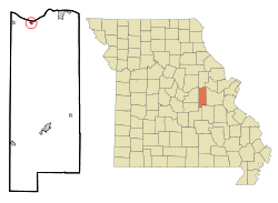
 Location of Gasconade, Missouri | |
| Coordinates: 38°40′13″N 91°33′36″W / 38.67028°N 91.56000°W | |
| Country | United States |
| State | Missouri |
| County | Gasconade |
| Area | |
• Total | 0.20 sq mi (0.53 km2) |
| • Land | 0.20 sq mi (0.53 km2) |
| • Water | 0.00 sq mi (0.00 km2) |
| Elevation | 528 ft (161 m) |
| Population | |
• Total | 172 |
| • Density | 847.29/sq mi (327.22/km2) |
| Time zone | UTC-6 (Central (CST)) |
| • Summer (DST) | UTC-5 (CDT) |
| ZIP codes | 65036, 65061 |
| Area code | 573 |
| FIPS code | 29-26578[4] |
| GNIS feature ID | 2394867[2] |
Gasconade is a city in Gasconade County, Missouri. The population is 172 as of the 2020 census.[5]
- ^ "ArcGIS REST Services Directory". United States Census Bureau. Retrieved October 11, 2022.
- ^ a b U.S. Geological Survey Geographic Names Information System: Gasconade, Missouri
- ^ Cite error: The named reference
USCensusDecennial2020CenPopScriptOnlywas invoked but never defined (see the help page). - ^ "U.S. Census website". United States Census Bureau. Retrieved January 31, 2008.
- ^ "Explore Census Data". data.census.gov. Retrieved January 24, 2022.