Back جافدوس Arabic Gavdos AST Qavdos adası Azerbaijani Гавдос Bulgarian Gavdos Catalan Nisí Gávdos CEB Gavdos Czech Gavdos Danish Gavdos German Γαύδος Greek
Gavdos
Γαύδος | |
|---|---|
 Satellite image of Gavdos | |
| Coordinates: 34°50′N 24°05′E / 34.833°N 24.083°E | |
| Country | Greece |
| Administrative region | Crete |
| Regional unit | Chania |
| Area | |
• Municipality | 32.4 km2 (12.5 sq mi) |
| Highest elevation | 345 m (1,132 ft) |
| Lowest elevation | 0 m (0 ft) |
| Population (2021)[1] | |
• Municipality | 142 |
| • Density | 4.4/km2 (11/sq mi) |
| Time zone | UTC+2 (EET) |
| • Summer (DST) | UTC+3 (EEST) |
| Postal code | 730 01 |
| Area code(s) | 28230 |
| Vehicle registration | ΧΝ |
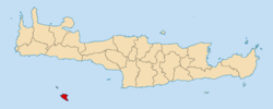
Gavdos (Greek: Γαύδος, [ˈɣavðos]) is the southernmost Greek island, located to the south of its much larger neighbour, Crete, of which it is administratively a part, in the regional unit of Chania. It forms a community with surrounding islets and was part of the former Selino Province.
- ^ "Αποτελέσματα Απογραφής Πληθυσμού - Κατοικιών 2021, Μόνιμος Πληθυσμός κατά οικισμό" [Results of the 2021 Population - Housing Census, Permanent population by settlement] (in Greek). Hellenic Statistical Authority. 29 March 2024.

