Back Geografie van die Verenigde State Afrikaans جغرافيا الولايات المتحدة Arabic ABŞ coğrafiyası Azerbaijani Геаграфія ЗША Byelorussian География на Съединените американски щати Bulgarian মার্কিন যুক্তরাষ্ট্রের ভূগোল Bengali/Bangla Geografija Sjedinjenih Američkih Država BS Geografia dels Estats Units Catalan جوگرافیای ویلایەتە یەکگرتووەکانی ئەمریکا CKB Geografie Spojených států amerických Czech

 | |
| Continent | North America |
|---|---|
| Coordinates | 38°00′00″N 97°00′00″W / 38.000°N 97.000°W |
| Area | Ranked 3rd/4th |
| • Total | 9,826,675 km2 (3,794,100 sq mi) |
| • Land | 93.24% |
| • Water | 6.76% |
| Coastline | 19,920 km (12,380 mi) |
| Borders | Canada: 8,864 km (5,508 mi) Mexico: 3,327 km (2,067 mi) |
| Highest point | Denali 6,190.5 m (20,310 ft) |
| Lowest point | Badwater Basin, −85 m (−279 ft) |
| Longest river | Missouri River, 3,767 km (2,341 mi) |
| Largest lake | (shared) Lake Superior 58,000 km2 (22,394 sq mi) (internal) Iliamna Lake 2,600 km2 (1,004 sq mi) |
| Climate | Diverse: Ranges from warm-summer continental in the far north to tropical in the far south. West: mostly semi-arid to desert, Mountains: alpine, Northeast: humid continental, Southeast: humid subtropical, Coast of California: Mediterranean, Pacific Northwest: cool temperate oceanic, Alaska: mostly subarctic, Hawaii, South Florida, and the territories: tropical |
| Terrain | Vast central plain, Interior Highlands and low mountains in Midwest, mountains and valleys in the mid-south, coastal flatland near the Gulf and Atlantic coasts, complete with mangrove forests and temperate, subtropical, and tropical laurel forest and jungle, canyons, basins, plateaus, and mountains in west, hills and low mountains in east; intermittent hilly and mountainous regions in Great Plains, with occasional badland topography; rugged mountains and broad river valleys in Alaska; rugged, volcanic topography in Hawaii and the territories |
| Natural resources | Coal, copper, lead, molybdenum, phosphates, rare earth elements, uranium, bauxite, gold, iron, mercury, nickel, potash, silver, tungsten, zinc, petroleum, natural gas, timber, arable land |
| Natural hazards | Tsunamis; volcanoes; earthquake activity around Pacific Basin; hurricanes along the Atlantic and Gulf of Mexico coasts; severe convective thunderstorms and tornadoes in the Midwest, Great Plains and Southeast; mud slides in California; forest and brush fires in the west and central regions, especially; flooding; dust storms in western and central regions; permafrost in northern Alaska |
| Environmental issues | Environmental issues Deforestation, energy irresponsibility, pollution, nuclear waste, Severe water shortages, air pollution resulting in acid rain in both the US and Canada |
| Exclusive economic zone | 11,351,000 km2 (4,383,000 sq mi) |
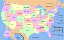
The term "United States," when used in the geographic sense, refers to the contiguous United States (sometimes referred to as the Lower 48, including the District of Columbia not as a state), Alaska, Hawaii, the five insular territories of Puerto Rico, Northern Mariana Islands, U.S. Virgin Islands, Guam, American Samoa, and minor outlying possessions.[1] The United States shares land borders with Canada and Mexico and maritime borders with Russia, Cuba, the Bahamas, and many other countries, mainly in the Caribbean[note 2]in addition to Canada and Mexico. The northern border of the United States with Canada is the world's longest bi-national land border.
Cite error: There are <ref group=note> tags on this page, but the references will not show without a {{reflist|group=note}} template (see the help page).
- ^ U.S. State Department, Common Core Document to U.N. Committee on Human Rights, December 30, 2011, Item 22, 27, 80; Homeland Security Public Law 107-296 Sec.2.(16)(A); Presidential Proclamation of national jurisdiction [1]
- ^ https://www.britannica.com/place/United-States-Virgin-Islands. Britannica.com. United States Virgin Islands. Retrieved July 3, 2020. Archived April 29, 2020, at the Wayback Machine
- ^ https://www.britannica.com/place/Puerto-RicoBritannica.com. Puerto Rico. Retrieved July 3, 2020. Archived July 2, 2020, at the Wayback Machine
- ^ Anderson, Ewan W. (2003). International Boundaries: A Geopolitical Atlas. Routledge: New York. ISBN 9781579583750; OCLC 54061586
- ^ Charney, Jonathan I., David A. Colson, Robert W. Smith. (2005). International Maritime Boundaries, 5 vols. Hotei Publishing: Leiden.
- ^ http://www.pacgeo.org/static/maritimeboundaries/Pacgeo.org. Maritime Boundaries. Retrieved July 3, 2020. Archived July 31, 2020, at the Wayback Machine