Back Gesundbrunnen CEB Berlin-Gesundbrunnen German گزوندبرونن (برلین) Persian Berlin-Gesundbrunnen French Gesundbrunnen Italian Berlin-Gesundbrunnen Dutch Gesundbrunnen NB Gesundbrunnen (Berlin) Polish Gesundbrunnen Portuguese Гезундбруннен (Берлин) Russian
Gesundbrunnen | |
|---|---|
 Panorama from the Humboldthain | |
| Coordinates: 52°32′55″N 13°23′25″E / 52.54861°N 13.39028°E | |
| Country | Germany |
| State | Berlin |
| City | Berlin |
| Borough | Mitte |
| Founded | 1251 |
| Area | |
• Total | 6.13 km2 (2.37 sq mi) |
| Elevation | 52 m (171 ft) |
| Population (2023-12-31)[1] | |
• Total | 95,832 |
| • Density | 16,000/km2 (40,000/sq mi) |
| Time zone | UTC+01:00 (CET) |
| • Summer (DST) | UTC+02:00 (CEST) |
| Postal codes | 13347, 13355, 13357, 13359, 13409 |
| Vehicle registration | B |
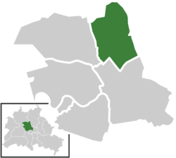
Gesundbrunnen (German: [ɡəˈzʊntˌbʁʊnən] ⓘ, literally "health springs"; colloquially Plumpe, "pump") is a locality (Ortsteil) of Berlin in the borough (Bezirk) of Mitte. It was created as a separate entity during the 2001 administrative reform, formerly the eastern half of the former Wedding district (merged into Mitte) and locality. Gesundbrunnen has the highest percentage of non-German residents of any Berlin locality, at 35.1% as of the end of 2008.[2]
- ^ "Einwohnerinnen und Einwohner im Land Berlin am 31. Dezember 2023". Amt für Statistik Berlin-Brandenburg. February 2024.
- ^ (in German) In-Berlin-Brandenburg.com, Wie viele Ausländer gibt es in Berlin? Retrieved 2009-10-27.


