Back تل الجزر Arabic تل الجزر ARZ Гезер Bulgarian Guèzer Catalan Tel Gezer CEB Gezer Czech Gezer German Gézer Spanish Gezer Basque گزر (تل الجزر) Persian
גֶּזֶר | |
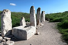
 The Gezer High Place with stone monoliths and basin | |
| Alternative name | Tel Gezer (Heb.), Tell Jezer/Tell el-Jazari (Ar.) |
|---|---|
| Location | |
| Coordinates | 31°51′32.4″N 34°55′8.4″E / 31.859000°N 34.919000°E |
| Grid position | 142/140 PAL |
| Site notes | |
| Condition | Ruin |
Gezer, or Tel Gezer (Hebrew: גֶּזֶר), in Arabic: تل الجزر – Tell Jezar or Tell el-Jezari is an archaeological site in the foothills of the Judaean Mountains at the border of the Shfela region roughly midway between Jerusalem and Tel Aviv. It is now an Israeli national park. In the Hebrew Bible, Gezer is associated with Joshua and Solomon.
The archaeological site of Tel Gezer rises to an elevation of 229 metres (751 ft) above sea-level, and affords a commanding prospect of the plains to the west, north and east.
Gezer became a major fortified Canaanite city-state in the first half of the 2nd millennium BCE. It was later destroyed by fire and rebuilt. It is first mentioned in several ancient Egyptian inscriptions. Its importance was due in part to the strategic position it held at the crossroads of the ancient coastal trade route linking Egypt with Syria, Anatolia and Mesopotamia, and the road to Jerusalem and Jericho, both important trade routes. In Roman and Byzantine times, the site was sparsely populated. Later, In the modern era, Tel Gezer was the site of the Palestinian village of Abu Shusheh, the residents of which were expelled by Israeli forces during the 1948 Arab–Israeli War.
