Back غلينديل (يوتا) Arabic جلينديل ARZ قلندئیل، یوتا AZB Glendale (Utah) Catalan Глендейл (Юта) CE Glendale (lungsod sa Tinipong Bansa, Utah) CEB Glendale, Utah Welsh Glendale (Utah) Spanish Glendale (Utah) Basque گلندیل، یوتا Persian
Glendale, Utah | |
|---|---|
 U.S. Route 89 passing through Glendale | |
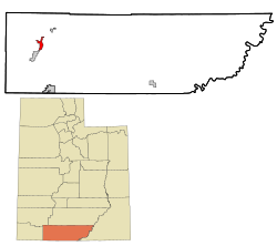
 Location in Kane County and the state of Utah | |
 Location of Utah in the United States | |
| Coordinates: 37°19′55″N 112°36′5″W / 37.33194°N 112.60139°W | |
| Country | United States |
| State | Utah |
| County | Kane |
| Founded | 1862 |
| Incorporated | March 29, 1935 |
| Area | |
• Total | 7.00 sq mi (18.12 km2) |
| • Land | 7.00 sq mi (18.12 km2) |
| • Water | 0.00 sq mi (0.00 km2) |
| Elevation | 5,778 ft (1,761 m) |
| Population (2010) | |
• Total | 381 |
• Estimate (2019)[2] | 407 |
| • Density | 58.18/sq mi (22.46/km2) |
| Time zone | UTC-7 (Mountain (MST)) |
| • Summer (DST) | UTC-6 (MDT) |
| ZIP code | 84729 |
| Area code | 435 |
| FIPS code | 49-29360[3] |
| GNIS feature ID | 1428204[4] |
Glendale is a town in Kane County, Utah, United States. The population was 381 at the 2010 census.[5]
- ^ "2019 U.S. Gazetteer Files". United States Census Bureau. Retrieved August 7, 2020.
- ^ Cite error: The named reference
USCensusEst2019CenPopScriptOnlyDirtyFixDoNotUsewas invoked but never defined (see the help page). - ^ "U.S. Census website". United States Census Bureau. Retrieved January 31, 2008.
- ^ "US Board on Geographic Names". United States Geological Survey. October 25, 2007. Retrieved January 31, 2008.
- ^ "Geographic Identifiers: 2010 Census Summary File 1 (G001), Glendale town, Utah". American FactFinder. U.S. Census Bureau. Archived from the original on February 13, 2020. Retrieved May 21, 2019.