Back قولدرز قرین AZB Golders Green Danish Golders Green Spanish Golders Green Basque گولدرز گرین Persian Golders Green French Golders Green Irish גולדרס גרין HE गोल्डर्स ग्रीन Hindi Golders Green Italian
| Golders Green | |
|---|---|
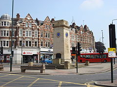
 Golders Green clock tower | |
 | |
Location within Greater London | |
| Population | 18,818 (2011 Census.Ward)[1] |
| OS grid reference | TQ248876 |
| London borough | |
| Ceremonial county | Greater London |
| Region | |
| Country | England |
| Sovereign state | United Kingdom |
| Post town | LONDON |
| Postcode district | NW11, NW2 |
| Dialling code | 020 |
| Police | Metropolitan |
| Fire | London |
| Ambulance | London |
| UK Parliament | |
| London Assembly | |
Golders Green is an area in the London Borough of Barnet in England. It began as a medieval small suburban linear settlement near a farm and public grazing area green, and dates to the early 19th century. Its bulk forms a late 19th century and early 20th century suburb with a commercial crossroads. The rest is of later build. It is centred approximately 6 miles (9 km) north west of Charing Cross on the intersection of Golders Green Road and Finchley Road.
It was founded as a medieval hamlet in the large parish of Hendon, Middlesex. The parish was heavily superseded by Hendon Urban District in 1894 and by the Municipal Borough of Hendon in 1932, abolished in 1965. In the early 20th century, it grew rapidly in response to the opening of a tube station of the London Underground, adjacent to the Golders Green Hippodrome which was home to the BBC Concert Orchestra for many years. The area has a wide variety of housing and a busy main shopping street, Golders Green Road.
It is known for its large Jewish population as well as for being home to the largest Jewish kosher hub (located west of Hoop Lane after the rail bridge) in the United Kingdom, which attracts many Jewish tourists.
- ^ "Barnet Ward population 2011". Neighbourhood Statistics. Office for National Statistics. Archived from the original on 21 October 2016. Retrieved 19 October 2016.
