Back غولدفيلد (نيفادا) Arabic جولدفيلد, نيفادا ARZ قولدفیلد، نوادا AZB Goldfield (kapital sa kondado) CEB Goldfield (Nevada) Czech Goldfield (Nevada) German Goldfield (Nevada) Spanish Goldfield Estonian Goldfield (Nevada) Basque گلدفیلد، نوادا Persian
This article needs additional citations for verification. (November 2022) |
Goldfield | |
|---|---|
 Esmeralda County Courthouse in Goldfield | |
Goldfield is located in the Tonopah Basin of Nevada. | |
| Coordinates: 37°42′31″N 117°14′08″W / 37.70861°N 117.23556°W | |
| Country | |
| State | |
| County | Esmeralda |
| Founded | 1902 |
| Named for | Gold |
| Area | |
• Total | 1.48 sq mi (3.84 km2) |
| • Land | 1.48 sq mi (3.84 km2) |
| • Water | 0.00 sq mi (0.00 km2) |
| Elevation | 5,686 ft (1,733 m) |
| Population (2020) | |
• Total | 225 |
| • Density | 151.92/sq mi (58.66/km2) |
| Time zone | UTC−8 (PST) |
| • Summer (DST) | UTC−7 (PDT) |
| ZIP code | 89013 |
| Area code | 775 |
| FIPS code | 32-28900 |
| GNIS feature ID | 854468[2] |


Goldfield is an unincorporated town and census-designated place and the county seat of Esmeralda County, Nevada.
It is the locus of the Goldfield CDP which had a resident population of 268 at the 2010 census,[3] down from 440 in 2000. Goldfield is located 247 miles (398 km) southeast of Carson City, along U.S. Route 95.
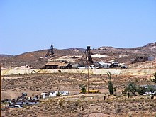
Goldfield was a boomtown in the first decade of the 20th century due to the discovery of gold – between 1903 and 1940, Goldfield's mines produced more than $86 million at then-current prices. Much of the town was destroyed by a fire in 1923, although several buildings survived and remain today, notably the Goldfield Hotel, the Consolidated Mines Building (the communications center of the town until 1963), and the schoolhouse. Gold exploration continues in and around the town today.
- ^ "ArcGIS REST Services Directory". United States Census Bureau. Retrieved September 19, 2022.
- ^ a b U.S. Geological Survey Geographic Names Information System: Goldfield, Nevada
- ^ "Geographic Identifiers: 2010 Demographic Profile Data (G001): Goldfield CDP, Nevada". U.S. Census Bureau, American Factfinder. Retrieved February 16, 2016.[dead link]

