Back جوربيا Arabic جبل جوربيا ARZ Gorbeia Catalan Gorbeia CEB Gorbea (Berg) German Monte Gorbea Spanish Gorbeia Basque Gorbeia French Gorbeia Galician Գորբեա Armenian
| Gorbea | |
|---|---|
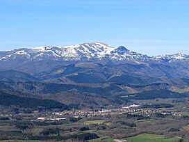
 Gorbea rising over Otxandio | |
| Highest point | |
| Elevation | 1,482 m (4,862 ft)[1] |
| Prominence | 866 m (2,841 ft)[1] |
| Isolation | 37.6 km (23.4 mi)[1] |
| Coordinates | 43°02′06″N 2°46′48″W / 43.035°N 2.77988°W |
| Naming | |
| Native name | Gorbeia (Basque) |
| Geography | |
| Parent range | Basque Mountains |
| Climbing | |
| Easiest route | Hike |
Gorbea (Spanish pronunciation: [goɾˈβea]) or Gorbeia (Basque pronunciation: [gorβei.a]) is a mountain and massif in the Basque Country, Spain. It is the highest summit in Biscay and Álava, with a height of 1,482 metres (4,862 ft) above sea level. The massif covers a wide area between the two provinces. The main summit is a round grass-covered mountain crowned by a 17-metre-tall metallic cross. Historically, it was one of the five montes bocineros of Biscay, from where meetings to the Juntas Generales of the Lordship of Biscay were announced.[2]
To the north of the massif lies the karstic plateau of Itxina, an area full of shafts and caves such as Supelegor. The southern side of the mountain is less craggy, being covered by forests. Other notable mountains of the massif are Berretin to the south and the Lekanda and Aldamin limestone peaks to the north.
Since 1994, the whole massif has been part of the Gorbeia Natural Park, established to preserve the local beech and oak forests as well as the populations of wild boars and deer. Its status as the highest summit in two provinces and easy access have made it one of the most emblematic mountains in the Basque Country.[3][4]
- ^ a b c "Gorbeia, Spain". Peakbagger.com.
- ^ Muñoyerro, Íñigo (20 July 2007). "Los montes bocineros". El Correo (in Spanish). Retrieved 9 October 2022.
- ^ J. Pérez, Fernando (14 November 2021). "La cruz del Gorbea: 120 años como faro del montañismo" (in Spanish). Retrieved 25 September 2022.
- ^ Molano, Eva (13 November 2021). "La Cruz del Gorbea, querida por todos". El Correo (in Spanish). Retrieved 25 September 2022.

