Back Gorgona (Colombia) Afrikaans جزيرة غورغونا Arabic جورجونا (جزيره) ARZ Illa Gorgona Catalan Isla Gorgona (pulo sa Kolombiya) CEB Gorgona (Kolumbie) Czech Gorgona (Kolumbien) German Isla Gorgona Spanish Gorgona uhartea Basque Île Gorgona French
| Gorgona National Natural Park | |
|---|---|
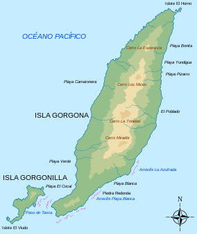
 Map of the island | |
| Location | Pacific Ocean |
| Nearest city | Guapí, Cauca |
| Coordinates | 02°58′03″N 78°10′49″W / 2.96750°N 78.18028°W |
| Area | 620 km2 (240 sq mi) marine 26 km2 (10 sq mi) land |
| Established | 1984 |
| Governing body | SINAP |
Gorgona is a Colombian island in the Pacific Ocean situated about 28 km (17 mi) off the Colombian Pacific coast. The island is 9 km (5.6 mi) long and 2.5 km (1.6 mi) across at its widest, with a maximum height of 338 m (1,109 ft) and a total area of 26 km2 (10 sq mi). Gorgona is separated from the continent by a 270 m (890 ft) deep underwater depression.
Administratively, the island is part of the Municipality of Guapí in the Department of Cauca. Gorgona functioned as a prison from 1959 until 1984 when it was turned into a National Natural Park. The island, noted for its many endemic species and unique ecosystems, was established as Gorgona Island National Park in 1985, in order to preserve its richly varied wildlife of the sub-tropical forest and the coral reefs offshore.

