| Gospel Hump Wilderness | |
|---|---|
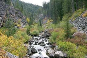
 Crooked Creek in Gospel Hump Wilderness | |
| Location | Idaho County, Idaho, United States |
| Nearest city | Elk City, Idaho |
| Coordinates | 45°33′57″N 115°46′32″W / 45.56583°N 115.77556°W |
| Area | 205,796 acres (832.83 km2) |
| Established | February 24, 1978 |
| Governing body | U.S. Forest Service |
The Gospel Hump Wilderness is a federally-protected wilderness area that covers 205,796 acres (83,283 ha) of the state of Idaho.[1] Managed by the U.S. Forest Service in the U.S. Department of Agriculture, it received wilderness designation on February 24, 1978 through the passage of the Endangered American Wilderness Act and is part of Nez Perce National Forest.[2][3] As part of the National Wilderness Preservation System, the Gospel Hump Wilderness is an area where human development and use are restricted and people are to remain only visitors.[4]
- ^ "Gospel Hump Wilderness". Geographic Names Information System. United States Geological Survey, United States Department of the Interior. Retrieved September 20, 2014.
- ^ "Gospel-Hump Wilderness" (PDF). U.S. Forest Service. Archived from the original (PDF) on September 24, 2015. Retrieved September 20, 2014.
- ^ "Public Law 95-237" (PDF). U.S. Congress. Archived from the original (PDF) on September 23, 2015. Retrieved September 20, 2014.
- ^ Zahniser, Howard (September 3, 1964). "The Wilderness Act" (PDF). Washington, DC: U.S. Congress. Archived from the original (PDF) on February 14, 2013. Retrieved May 22, 2012.

