Back Granville County, Noord-Carolina Afrikaans مقاطعة غرانفيل (كارولاينا الشمالية) Arabic Granville County, North Carolina BAR Гранвил (окръг) Bulgarian গ্রানভিল কাউন্টি, নর্থ ক্যারোলাইনা BPY Granville Gông (North Carolina) CDO Гранвилл (гуо, Къилбаседа Каролина) CE Granville County CEB Granville County, Gogledd Carolina Welsh Granville County German
Granville County | |
|---|---|
 | |
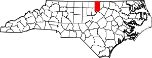
 Location within the U.S. state of North Carolina | |
 North Carolina's location within the U.S. | |
| Coordinates: 36°18′N 78°40′W / 36.30°N 78.66°W | |
| Country | |
| State | |
| Established | June 28, 1746 |
| Named for | John Carteret, 2nd Earl Granville |
| Seat | Oxford |
| Largest community | Oxford |
| Area | |
• Total | 537.59 sq mi (1,392.4 km2) |
| • Land | 531.99 sq mi (1,377.8 km2) |
| • Water | 5.60 sq mi (14.5 km2) 1.04% |
| Population (2020) | |
• Total | 60,992 |
• Estimate (2023) | 62,192 |
| • Density | 110/sq mi (44/km2) |
| Congressional district | 4th |
| Website | granvillecounty |
Granville County is a county located on the northern border of the U.S. state of North Carolina. As of the 2020 census, the population was 60,992.[1] Its county seat is Oxford.[2] The county has access to Kerr Lake and Falls Lake and is part of the Roanoke, Tar and Neuse River watersheds.
- ^ Cite error: The named reference
2020CensusQuickFactswas invoked but never defined (see the help page). - ^ "Find a County". National Association of Counties. Archived from the original on May 31, 2011. Retrieved June 7, 2011.

