This article includes a list of references, related reading, or external links, but its sources remain unclear because it lacks inline citations. (September 2022) |
| Grizedale Forest | |
|---|---|
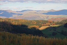
 View of the northern part of Grizedale Forest | |
 | |
| Location | Lake District, England |
| Nearest city | Lancaster, Lancashire |
| Coordinates | 54°20′25″N 3°01′25″W / 54.34028°N 3.02361°W |
| Area | 24.47 km² |
| Visitors | 200,000 (in 2006) |
| Governing body | National Trust and the Lake District National Park Authority |
Grizedale Forest is a 24.47 km2 area of woodland in the Lake District of North West England, located to the east of Coniston Water and to the south of Hawkshead. Historically, within the county of Lancashire, it now lies in the Westmorland and Furness district of Cumbria. It is made up of a number of hills, small tarns and the settlements of Grizedale and Satterthwaite. It is owned and managed by Forestry England and is a popular tourist destination with waymarked footpaths, mountain biking, an aerial assault course, a 16-bed hostel, and a visitor centre with a children's playground, education centre, café and shop. The car-parking of Grizedale Forest Visitors Centre is situated on the site of the former Grizedale Hall where its remains can be still seen.
In past years, several stages on the WRC RAC Rally were held on tracks through Grizedale Forest every winter. Weather permitting, the forest continues to be used for two annual rallies: the Malcolm Wilson Rally and the Grizedale Stages Rally, based in Coniston.
The forest retains large expanses of commercial forestry trees such as sitka spruce and western hemlock, although more recent plantations of deciduous native trees have been made. Larch and ash dieback diseases have brought significant clearances in some areas. The forest is home to many birds and mammals including buzzards, sparrow hawks, owls, woodpeckers, woodcock, grouse, red and grey squirrels, pine martens, badgers, stoats, foxes, red and roe deer.
