Back Groningen (propinsi) ACE Groningen (provinsie) Afrikaans Provincia de Groningen AN مقاطعة خرننغن Arabic مقاطعة خرونينجين ARZ Qroninqen (əyalət) Azerbaijani Groningen (propinsi) BAN Гронінген (правінцыя) Byelorussian Гронінген (правінцыя) BE-X-OLD Гронинген (провинция) Bulgarian
Province of Groningen
| |
|---|---|
| Anthem: "Grönnens Laid" "Song of Groningen" | |
 Location of Groningen in the Netherlands | |
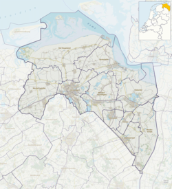
 Topography map of Groningen | |
| Coordinates: 53°15′N 6°44′E / 53.250°N 6.733°E | |
| Country | Netherlands |
| Capital (and largest city) | Groningen |
| Government | |
| • King's Commissioner | René Paas (CDA) |
| • Council | States of Groningen |
| Area (2023)[2] | |
• Total | 2,955 km2 (1,141 sq mi) |
| • Land | 2,316 km2 (894 sq mi) |
| • Water | 639 km2 (247 sq mi) |
| • Rank | 7th |
| Population (1 January 2023) | |
• Total | 596,075[1] |
| • Rank | 9th |
| • Density | 257/km2 (670/sq mi) |
| • Rank | 9th |
| GDP | |
| • Total | €25.636 billion |
| • Per capita | €44,000 |
| Time zone | UTC+1 (CET) |
| • Summer (DST) | UTC+2 (CEST) |
| ISO 3166 code | NL-GR |
| HDI (2021) | 0.930[4] very high · 5th of 12 |
| Website | www |
Groningen (/ˈɡroʊnɪŋən/ GROH-ning-ən, UK also /ˈɡrɒnɪŋən/ GRON-ing-ən,[5][6] Dutch: [ˈɣroːnɪŋə(n)] ⓘ; Gronings: Grunn; West Frisian: Grinslân [ˈɡrẽːslɔ̃ːn]) is the northeasternmost province of the Netherlands. It borders on Friesland to the west, Drenthe to the south, the German state of Lower Saxony to the east, and the Wadden Sea to the north. As of January 2023, Groningen had a population of about 596,000,[7] and a total area of 2,955 km2 (1,141 sq mi).
Historically the area was at different times part of Frisia, the Frankish Empire, the Holy Roman Empire, and the Dutch Republic, the precursor state of the modern Netherlands. In the 14th century, the city of Groningen became a member of the Hanseatic League.
The provincial capital and the largest city in the province is the city of Groningen (231,299 inhabitants[8]). Since 2016, René Paas has been the King's Commissioner in the province. A coalition of GroenLinks, the Labour Party, ChristianUnion, People's Party for Freedom and Democracy, Democrats 66, and Christian Democratic Appeal forms the executive branch. The province is divided into 10 municipalities.
The land is mainly used for agriculture. There are seaports in Delfzijl and Eemshaven. The Groningen gas field, one of the world's largest, was discovered in 1959. The province is home to the University of Groningen and Hanze University of Applied Sciences.
- ^ "CBS Statline". opendata.cbs.nl.
- ^ Statistieken provincie Groningen - Gegevens over meer dan 100 onderwerpen!, AlleCijfers.nl
- ^ "EU regions by GDP, Eurostat". Retrieved 18 September 2023.
- ^ "Sub-national HDI - Area Database - Global Data Lab". hdi.globaldatalab.org. Retrieved 13 September 2018.
- ^ "Groningen". The American Heritage Dictionary of the English Language (5th ed.). HarperCollins. Retrieved 1 May 2019.
- ^ "Groningen" Archived 1 May 2019 at the Wayback Machine (US) and "Groningen". Oxford Dictionaries UK English Dictionary. Oxford University Press. n.d. Retrieved 1 May 2019.
- ^ "CBS StatLine". opendata.cbs.nl.
- ^ "CBS Statline". opendata.cbs.nl.

