Back Gunnedah (rehiyon) CEB Gunnedah Shire German Comté de Gunnedah French Contea di Gunnedah Italian Gunnedah Shire Council Dutch Gunnedah Shire Swedish
| Gunnedah Shire New South Wales | |||||||||||||||
|---|---|---|---|---|---|---|---|---|---|---|---|---|---|---|---|
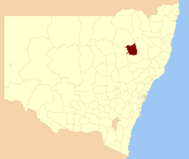
 Location in New South Wales | |||||||||||||||
| Coordinates | 30°58′S 150°15′E / 30.967°S 150.250°E | ||||||||||||||
| Population | 12,929 (2021 census)[1] | ||||||||||||||
| • Density | 2.5889/km2 (6.7052/sq mi) | ||||||||||||||
| Established | 1 January 1980 | ||||||||||||||
| Area | 4,994 km2 (1,928.2 sq mi) | ||||||||||||||
| Mayor | Colleen Fuller | ||||||||||||||
| Council seat | Gunnedah[2] | ||||||||||||||
| Region | North West Slopes | ||||||||||||||
| State electorate(s) | Tamworth | ||||||||||||||
| Federal division(s) | Parkes | ||||||||||||||
 | |||||||||||||||
| Website | Gunnedah Shire | ||||||||||||||
| |||||||||||||||
Gunnedah Shire is a local government area in the North West Slopes region of New South Wales, Australia. The Shire is located adjacent to the Liverpool Plains in the Namoi River valley and is traversed by the Oxley Highway and the Kamilaroi Highway.
The Shire was established in 1980 from the amalgamation of the Municipality of Gunnedah and Liverpool Plains Shire.[3] It includes the town of Gunnedah and surrounding villages of Curlewis, Breeza, Carroll, Mullaley, Emerald Hill, Tambar Springs and Kelvin.
The mayor of Gunnedah is councillor Jamie Chaffey, an Independent National.[4]
- ^ Australian Bureau of Statistics (28 June 2022). "Gunnedah (A)". 2021 Census QuickStats. Retrieved 7 April 2024.
- ^ "Gunnedah Shire Council". Division of Local Government. Retrieved 10 November 2006.
- ^ Hobson, Marie (2 May 2013). "The 'heart and soul' of Gunnedah". The Sydney Morning Herald. Retrieved 21 May 2016.
- ^ http://www.gunnedah.nsw.gov.au/index.php/council/keep-in-touch/news-media/item/1099-councillor-jamie-chaffey-elected-as-mayor-of-gunnedah-shire [dead link]