Back হবিগঞ্জ জেলা Bengali/Bangla হবিগঞ্জ জিলা BPY Habiganj (distrito) CEB Habiganj (Distrikt) German Distrikto Habiganj Esperanto Habiganj (zila) Spanish ناحیه هبیگنج Persian Habiganjin piirikunta Finnish Habiganj (district) French हबीगंज जिला Hindi
This article needs additional citations for verification. (September 2015) |
Habiganj District
হবিগঞ্জ জেলা | |
|---|---|
Clockwise from top-left: Uchail Mosque, Narikel Tea Garden, Satchari National Park, Tea garden in Bahubal Upazila | |
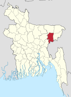
 Location of Habiganj District in Bangladesh | |
 Expandable map of Habiganj District | |
| Country | |
| Division | Sylhet Division |
| Headquarters | Habiganj |
| Government | |
| • Deputy Commissioner | Devi Chandra [1] |
| Area | |
• Total | 2,636.58 km2 (1,017.99 sq mi) |
| Population | |
• Total | 2,358,886 |
| • Density | 890/km2 (2,300/sq mi) |
| Demonym | Habiganji |
| Time zone | UTC+06:00 (BST) |
| Postal code | 3300 |
| Area code | 0831 |
| ISO 3166 code | BD-20 |
| HDI (2019) | 0.573[3] medium · 20th of 20 |
| Website | www |
Habiganj District (Bengali: হবিগঞ্জ জেলা; Bengali pronunciation: [Hobigonj Jela]), formerly known as Habibganj District (Bengali: হাবিবগঞ্জ জেলা), is a district in north-eastern Bangladesh, located in the Sylhet Division. It was established as a district in 1984 as a successor to its subdivision status since 1867. It is named after its founder, Syed Habib Ullah, son of Syed Hedayet Ullah, who is the founder of Sultani Habeli.[4]
- ^ "List of Deputy Commissioners". Bangladesh National Information Broadcasting.
- ^ Cite error: The named reference
2022censuswas invoked but never defined (see the help page). - ^ "Sub-national HDI - Area Database - Global Data Lab". hdi.globaldatalab.org. Retrieved 2020-03-18.
- ^ "Judiciary: Bangladesh". 2025-01-08. Archived from the original on 2025-01-08.


