| Hackney | |
|---|---|
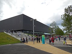
 The Copper Box Arena, in the Queen Elizabeth Olympic Park | |
Location within Greater London | |
| Population | 77,736 (2011 census)[1] |
| OS grid reference | TQ347845 |
| • Charing Cross | 4 mi (6.4 km) SW |
| London borough | |
| Ceremonial county | Greater London |
| Region | |
| Country | England |
| Sovereign state | United Kingdom |
| Post town | LONDON |
| Postcode district | E5, E8, E9, E20, N1, N16 |
| Dialling code | 020 |
| Police | Metropolitan |
| Fire | London |
| Ambulance | London |
| UK Parliament | |
| London Assembly | |
Hackney is a district in East London, England, forming around two-thirds of the area of the modern London Borough of Hackney, to which it gives its name. It is 4 miles (6.4 km) northeast of Charing Cross and includes part of the Queen Elizabeth Olympic Park. Historically it was within the county of Middlesex.
In the past it was also referred to as Hackney Proper to distinguish it from the village which subsequently developed in the vicinity of Mare Street, the term Hackney Proper being applied to the wider district.[2]
Hackney is a large district, whose long established boundaries encompass the sub-districts of Homerton, Dalston (including Kingsland and Shacklewell), De Beauvoir Town, Upper and Lower Clapton, Stamford Hill, Hackney Central, Hackney Wick, South Hackney and West Hackney.
- ^ "Hackney". Hidden London.
- ^ "The National Gazetteer of Great Britain and Ireland". 1868. Retrieved 20 February 2007.

