Back نهر هان Arabic نهر هان ARZ Ríu Han AST هان (کره) چایی AZB Ханган Byelorussian Хан (река) Bulgarian হান নদী (কোরিয়া) Bengali/Bangla Riu Han Catalan Han-gang (suba sa Amihanang Koreya) CEB ڕووباری ھان CKB
| Han River | |
|---|---|
 Satellite image of the Han river flowing through Seoul (upper half of image; 2006) | |
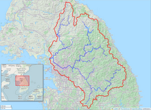
 The Han River watershed | |
| Etymology | Baekje Hanja, "Hansu" (漢水)[a][1] |
| Location | |
| Country | South Korea (KOR), North Korea (PRK) |
| Provinces | Gangwon Province (KOR), Gyeonggi Province (KOR), Seoul (KOR), North Hwanghae Province (PRK) |
| Physical characteristics | |
| Source | Taebaek Mountains |
| • location | Geumdae Peak, Taebaek, Gangwon Province, South Korea[b][2] |
| Mouth | Yellow Sea |
• location | Northwestern tip of Gimpo peninsula, KOR-PRK border[3] |
| Length | 508 km (316 mi)[4] |
| Basin size | 35,770 km2 (13,810 sq mi)[4] |
| Discharge | |
| • location | Hangang Bridge, Seoul[c][5] |
| • average | 613 m3/s (21,600 cu ft/s)[d][5] |
| Basin features | |
| Tributaries | |
| • left | Dalcheon, Cheongmicheon, Bokhacheon, Gyeongancheon, Anyangcheon, Ara Canal † |
| • right | Seom River, Bukhan River, Jungnangcheon, Gongneungcheon, Rimjin River |
| † : Distributary of Han
| |
| Korean name | |
| Hangul | 한강 |
| Hanja | 漢江 |
| Revised Romanization | Hangang |
| McCune–Reischauer | Han'gang |
The Han River (Korean: 한강; RR: Hangang) is a river in the central region of the Korean peninsula, with some of its tributaries and drainage basin in North Korea. It is classified as a national first-class river in South Korea. The Han River currently has eight river islands: Nanjido, Yeouido, Ttukseom, Nodeulseom, Seoraeseom, Sebitseom, Bamseom, and Seonyudo.[6]
The Han has the highest flow rate of any river on the Korean Peninsula and also has the largest basin area. In terms of length, It is the fourth longest river on the Korean peninsula after the Amnok, Tuman, and Nakdong rivers.[7] The river begins as two smaller rivers in the eastern mountains of the Korean peninsula, which then converge near Seoul.
Seoul, the capital city of South Korea, is the only example of a major metropolis with such a wide river running through it; few large cities are divided by a massive river approximately 1.2 kilometers wide.[8] The term "Miracle on the Han River", referring to South Korea's rapid economic growth, originates from this river.
Cite error: There are <ref group=lower-alpha> tags or {{efn}} templates on this page, but the references will not show without a {{reflist|group=lower-alpha}} template or {{notelist}} template (see the help page).
- ^ 2013년 한국하천일람 [List of Rivers of South Korea, 2013] (PDF) (in Korean). Han River Flood Control Office, Republic of Korea. 31 December 2012. pp. 23–24. Archived from the original (PDF) on 4 March 2016. Retrieved 3 July 2014.
- ^ HRFCO 2012 Archived 2016-03-04 at the Wayback Machine, pp. 25, 28.
- ^ HRFCO 2012 Archived 2016-03-04 at the Wayback Machine, pp. 82-83.
- ^ a b HRFCO 2012 Archived 2016-03-04 at the Wayback Machine, pp. 22, 25, 33, 82-83.
- ^ a b 2014년 1월 월간 수자원 현황 및 전망 [Monthly Status & Predictions Report on Water Resources, January 2014] (in Korean). Han River Flood Control Office, Republic of Korea. 13 January 2014. p. 3. Archived from the original (HWP) on 15 July 2014. Retrieved 15 July 2014.
- ^ https://mediahub.seoul.go.kr/archives/2008024
- ^ Shin, Jung-il, "Historic River Flowing through the Korean Peninsula." Koreana (Summer, 2004), 6.
- ^ 서울의 한강이 갖는 특수성도 잘 살려져야 한다. 세계의 도시 속에 도시의 한가운데를 흐르는 1km나 넘는 강의 폭을 갖는 도시는 서울뿐이다. '99. 9. 월간서울 9월호 : 기획특집 「한강다리」 https://news.seoul.go.kr/safe/archives/823
