Back Haninge AST Ханінгэ (камуна) Byelorussian Ганінге (камуна) BE-X-OLD Ханинге (община) Bulgarian Haninge Kommun CEB Haninge kommun Danish Gemeinde Haninge German Municipio de Haninge Spanish Haninge vald Estonian Haninge udalerria Basque
Haninge Municipality
Haninge kommun | |
|---|---|
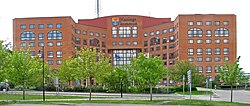
 Haninge City Hall | |
 | |
| Coordinates: 59°10′N 18°08′E / 59.167°N 18.133°E | |
| Country | Sweden |
| County | Stockholm County |
| Seat | Handen |
| Area | |
• Total | 2,160.87 km2 (834.32 sq mi) |
| • Land | 458.07 km2 (176.86 sq mi) |
| • Water | 1,702.8 km2 (657.5 sq mi) |
| Area as of 1 January 2014. | |
| Population (31 December 2023)[2] | |
• Total | 99,751 |
| • Density | 46/km2 (120/sq mi) |
| Demonyms |
|
| Time zone | UTC+1 (CET) |
| • Summer (DST) | UTC+2 (CEST) |
| ISO 3166 code | SE |
| Province | Södermanland |
| Municipal code | 0136 |
| Website | www.haninge.se |
| Density is calculated using land area only. | |
Haninge Municipality (Haninge kommun) is a municipality in Stockholm County in east central Sweden. Its seat is located in Handen, a part of the Stockholm urban area.
Haninge Municipality was formed in 1971 when Västerhaninge and Österhaninge were united.
The municipal coat of arms depicts a capercaillie from which the name Haninge is believed to have been derived (the German word hahn means capercaillie), while the anchor symbolizes the naval base in the municipality. The German word usage is supposedly from the old German Hansa traders who operated in the area.
- ^ "Statistiska centralbyrån, Kommunarealer den 1 januari 2014" (in Swedish). Statistics Sweden. 1 January 2014. Archived from the original (Microsoft Excel) on 27 September 2016. Retrieved 18 April 2014.
- ^ "Folkmängd och befolkningsförändringar - Kvartal 4, 2023" (in Swedish). Statistics Sweden. 22 February 2024. Retrieved 22 February 2024.
