Railway line in Germany
| Hanover freight bypass railway |
|---|
 |
|
| Native name | Güterumgehungsbahn Hannover |
|---|
| Line number | 1750 |
|---|
| Locale | Lower Saxony |
|---|
| Termini | |
|---|
|
| Route number | (only freight) |
|---|
|
| Line length | 43.3 km (26.9 mi) |
|---|
| Track gauge | 1,435 mm (4 ft 8+1⁄2 in) standard gauge |
|---|
| Electrification | 15 kV/16.7 Hz AC overhead catenary |
|---|
|
|
|
|
|
|
|
|
|
|
|
|
|
0.0
|
Wunstorf
|
|
|
|
|
|
|
|
|
|
|
4.0
|
Seelze-Gümmerwald (junction)
|
|
|
|
|
5,1
|
Dedensen-Gümmer
|
|
|
|
|
|
|
|
|
|
|
|
Seelze (separate S-Bahn line from here)
|
|
|
|
|
10.4
|
Seelze Rbf (marshalling yard) West
|
|
|
|
|
12.3
|
Seelze Rbf
|
|
|
|
|
|
|
|
|
|
|
|
Linden side canal
|
|
|
|
|
|
Connecting curve from Hannover-Hainholz
|
|
|
|
|
15.8
|
Ahlem
|
|
|
|
|
|
|
|
|
|
|
|
Linden port railway
|
|
|
|
|
|
|
|
|
|
|
19.8
|
Linden port
|
|
|
|
|
|
|
|
|
|
|
|
|
|
|
|
|
22.4
|
Hannover-Linden
|
|
|
|
|
23.2
|
Hannover-Linden/Fischerhof
|
|
|
|
|
|
To Lokalbahnhof/Hannover Süd until 1909
|
|
|
|
|
|
|
|
|
|
|
|
|
|
|
|
|
|
|
|
|
|
|
26.6
|
Hannover-Waldhausen (junction)
|
|
|
|
|
|
|
|
|
|
|
|
|
|
|
|
|
27.7
|
Hannover-Waldheim (junction)
|
|
|
|
|
|
|
|
|
|
|
|
|
|
|
|
|
|
|
|
|
|
|
|
Mittelland Canal
|
|
|
|
|
|
|
|
|
|
|
34.6
|
Misburg
|
|
|
|
|
|
|
|
|
|
|
|
|
|
|
|
|
|
Lehrte Rbf (planned Mega Hub)
|
|
|
|
|
40.8
|
Lehrte West (junction)
|
|
|
|
|
|
|
|
|
|
|
|
|
|
|
|
|
43.3
|
Lehrte Nord
|
|
|
|
|
|
|
|
|
|
|
|
|
|
|
|
| Source: German railway atlas[1]
| |
|
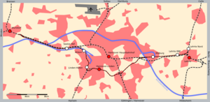
The Hanover freight bypass railway (German: Güterumgehungsbahn Hannover) is a freight railway in the German state of Lower Saxony, which relieves Hannover Hauptbahnhof of freight traffic. It separates freight from passenger traffic on several routes and runs through the western and southern outskirts of the city, bypassing the city centre and the main station.
- ^ Eisenbahnatlas Deutschland (German railway atlas) (2009/10 ed.). Schweers + Wall. 2009. ISBN 978-3-89494-139-0.
