Back Hardinxveld-Giessendam Afrikaans هاردينكسفيلد- خيسيندام Arabic Hardinxveld-Giessendam Catalan Gemeente Hardinxveld-Giessendam CEB Hardinxveld-Giessendam German Hardinxveld-Giessendam Esperanto Hardinxveld-Giessendam Spanish Hardinxveld-Giessendam Basque هاردینکسفلد-خیسندام Persian Hardinxveld-Giessendam French
Hardinxveld-Giessendam | |
|---|---|
![Water tower Hardinxveld [nl]](http://upload.wikimedia.org/wikipedia/commons/thumb/1/15/Hardinxveld_Watertoren_6853.JPG/250px-Hardinxveld_Watertoren_6853.JPG) | |
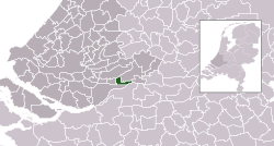
 Location in South Holland | |
| Coordinates: 51°49′N 4°50′E / 51.817°N 4.833°E | |
| Country | Netherlands |
| Province | South Holland |
| Established | 1 January 1957[1] |
| Government | |
| • Body | Municipal council |
| • Mayor | Dirk Heijkoop (CDA) |
| Area | |
• Total | 19.35 km2 (7.47 sq mi) |
| • Land | 16.91 km2 (6.53 sq mi) |
| • Water | 2.44 km2 (0.94 sq mi) |
| Elevation | 3 m (10 ft) |
| Population (January 2021)[5] | |
• Total | 18,413 |
| • Density | 1,089/km2 (2,820/sq mi) |
| Time zone | UTC+1 (CET) |
| • Summer (DST) | UTC+2 (CEST) |
| Postcode | 3370–3373 |
| Area code | 0184 |
| Website | www |

Hardinxveld-Giessendam (Dutch pronunciation: [ˈɦɑrdɪŋksfɛlt ˌxisə(n)ˈdɑm] ⓘ)[a] is a municipality in the western Netherlands, in the province of South Holland. It is located about 10 km east of Dordrecht, on the river Beneden-Merwede. The municipality had a population of 18,413 in 2021 and covers an area of 19.35 km2 (7.47 sq mi) of which 2.44 km2 (0.94 sq mi) is water.
The municipality of Hardinxveld-Giessendam consists of the two population centres Giessendam/Neder-Hardinxveld and Boven-Hardinxveld. Until they were merged in 1957,[6] Giessendam and Hardinxveld were two municipalities, consisting of only a few streets and dykes and only a few thousand inhabitants.
The town's economy is for a large part dependent on ship building (e.g. Damen Shipyards Group) and general contracting. Several industry parks are present.
- ^ "Historie" [History] (in Dutch). Gemeente Hardinxveld-Giessendam. Archived from the original on 10 May 2013. Retrieved 26 July 2013.
- ^ "Collegeleden" [Members of the board] (in Dutch). Gemeente Hardinxveld-Giessendam. Archived from the original on 10 May 2013. Retrieved 26 July 2013.
- ^ "Kerncijfers wijken en buurten 2020" [Key figures for neighbourhoods 2020]. StatLine (in Dutch). CBS. 24 July 2020. Retrieved 19 September 2020.
- ^ "Postcodetool for 3371AL". Actueel Hoogtebestand Nederland (in Dutch). Het Waterschapshuis. Retrieved 26 July 2013.
- ^ "Bevolkingsontwikkeling; regio per maand" [Population growth; regions per month]. CBS Statline (in Dutch). CBS. 1 January 2021. Retrieved 2 January 2022.
- ^ Ad van der Meer and Onno Boonstra, Repertorium van Nederlandse gemeenten, KNAW, 2011.
Cite error: There are <ref group=lower-alpha> tags or {{efn}} templates on this page, but the references will not show without a {{reflist|group=lower-alpha}} template or {{notelist}} template (see the help page).
