Back مقاطعة هارفورد (ماريلاند) Arabic Harford County, Maryland BAR Харфорд (окръг, Мериленд) Bulgarian হারফোর্ড কাউন্টি, মেরিল্যান্ড BPY Harford Gông (Maryland) CDO Харфорд (гуо, Мэриленд) CE Harford County CEB Harford County, Maryland Welsh Harford County German Κομητεία Χάρφορντ (Μέριλαντ) Greek
Harford County | |
|---|---|
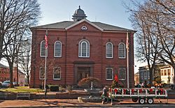
 Harford County Courthouse | |
 Location within the U.S. state of Maryland | |
 Maryland's location within the U.S. | |
| Coordinates: 39°32′N 76°18′W / 39.54°N 76.30°W | |
| Country | |
| State | |
| Founded | December 17, 1773 |
| Named for | Henry Harford |
| Seat | Bel Air |
| Largest city | Aberdeen |
| Area | |
• Total | 527 sq mi (1,360 km2) |
| • Land | 437 sq mi (1,130 km2) |
| • Water | 90 sq mi (200 km2) 17% |
| Population (2020) | |
• Total | 260,924 |
• Estimate (2023) | 264,644 |
| • Density | 500/sq mi (190/km2) |
| Time zone | UTC−5 (Eastern) |
| • Summer (DST) | UTC−4 (EDT) |
| Congressional district | 1st |
| Website | www |
Harford County is a county located in the U.S. state of Maryland. As of the 2020 census, the population was 260,924.[1] Its county seat is Bel Air.[2] Harford County is included in the Washington-Baltimore-Arlington, DC-MD-VA-WV-PA Combined Statistical Area. The county is part of the Central Maryland region of the state.
- ^ "State & County QuickFacts". United States Census Bureau. Retrieved August 13, 2021.
- ^ "Find a County". National Association of Counties. Retrieved June 7, 2011.

