Back نهر هاس ARZ Hase CEB Хазе CV Hase (flod) Danish Hase (Fluss) German Hase Esperanto Río Hase Spanish Hase jõgi Estonian هازه Persian Hase (rivière) French
| Hase | |
|---|---|
 Hase - Else River bifurcation | |
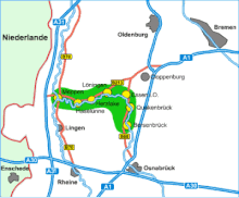
 Course of the Hase through the Hase Valley | |
| Etymology | haswa, germanic for gray |
| Location | |
| Country | Germany |
| State | Lower Saxony |
| Cities | |
| Physical characteristics | |
| Source | |
| • location | Melle-Wellingholzhausen, Teutoburg Forest |
| • coordinates | 52°7′57″N 8°15′53″E / 52.13250°N 8.26472°E |
| • elevation | 165 m (541 ft) |
| Mouth | Ems River |
• location | Meppen |
• coordinates | 52°41′28″N 7°17′48″E / 52.69111°N 7.29667°E |
• elevation | 15 m (49 ft) |
| Length | 169.7 km (105.4 mi)[1] |
| Basin size | 3,116 km2 (1,203 sq mi)[1][2] |
| Basin features | |
| Progression | Ems→ North Sea |
| Tributaries | |
| • right | Südradde, Mittelradde |
The Hase is a 169.7-kilometre-long (105.4 mi) river of Lower Saxony, Germany.[1] It is a right tributary of the Ems, but part of its flow goes to the Else, that is part of the Weser basin. Its source is in the Teutoburg Forest, south-east of Osnabrück, on the north slope of the 307-metre-high (1,007 ft) Hankenüll hill.
- ^ a b c Environmental map service of Lower Saxony (Umweltkartendienst des Niedersächsischen Ministeriums für Umwelt, Energie und Klimaschutz)
- ^ Hydrographic Directory of the NRW State Office for Nature, the Environment and Consumer Protection (Gewässerverzeichnis des Landesamtes für Natur, Umwelt und Verbraucherschutz NRW 2010) (xls; 4.67 MB)