Back هاتش (نيومكسيكو) Arabic هچ، نیومکزیکو AZB Hatch (Nou Mèxic) Catalan Hatch (lungsod sa Tinipong Bansa, New Mexico) CEB Hatch, New Mexico Welsh Hatch (New Mexico) German Hatch (Nuevo México) Spanish Hatch (Mexiko Berria) Basque هچ، نیومکزیکو Persian Hatch (Nouveau-Mexique) French
Hatch, New Mexico | |
|---|---|
 Hatch Municipal Building, June 2009 | |
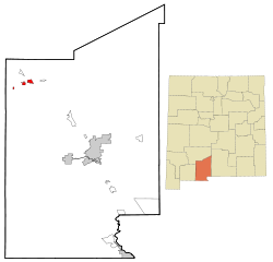
 Location within Doña Ana County and New Mexico | |
| Coordinates: 32°38′54″N 107°12′31″W / 32.64833°N 107.20861°W | |
| Country | United States |
| State | New Mexico |
| County | Doña Ana |
| Area | |
• Total | 3.06 sq mi (7.94 km2) |
| • Land | 3.00 sq mi (7.78 km2) |
| • Water | 0.06 sq mi (0.16 km2) |
| Elevation | 4,062 ft (1,238 m) |
| Population | |
• Total | 1,539 |
| • Density | 512.15/sq mi (197.75/km2) |
| Time zone | UTC-7 (Mountain (MST)) |
| • Summer (DST) | UTC-6 (MDT) |
| ZIP code | 87937 |
| Area code | Area code 575 |
| FIPS code | 35-31820 |
| GNIS ID | 2413557[2] |
| Website | villageofhatch.org |
Hatch is a village in Doña Ana County, New Mexico, United States. The population was 1,648 at the 2010 census. The town is experiencing moderate growth, along with its outliers of Salem, Arrey, Derry, and Rincon. Hatch is widely known as the "best chile place in the World," for growing a wide variety of peppers, especially the New Mexican cuisine staple, and one of New Mexico's state vegetables, the New Mexico chile.
- ^ "ArcGIS REST Services Directory". United States Census Bureau. Retrieved October 12, 2022.
- ^ a b U.S. Geological Survey Geographic Names Information System: Hatch, New Mexico
- ^ Cite error: The named reference
USCensusDecennial2020CenPopScriptOnlywas invoked but never defined (see the help page).
